Categories
kayaking paddling

What Goes Around Comes Around — New in the World of Paddling

The sport of paddling has come a long way from the birch bark canoe and the skin-on-frame kayak. Like a lot of things, as the sport has evolved, the trend has been toward increasing specialization. Way back when, you made that initial choice between a canoe or a kayak, and then you were set — or at least your grandfather would have you think it was so.

These days, when you buy a canoe, you choose between expedition, wilderness, tripping, recreational, whitewater, or racing. With kayaks, it is even better (or worse, depending on your perspective). You choose between whitewater, rec, sit-on-top, sit-in, touring, or sea kayak. If that’s not enough, you can select a surf ski, fitness kayak, women’s kayak, children’s kayak, or paddle board. Narrow it down to whitewater, and you still must decide between downriver, creek, play, squirt, or surf. Sea kayaks are high, medium, or low volume, and are for racing, touring, or play. You get the idea.

A funny thing happens though. When things diversify far enough, they start to merge or form hybrids — and that is the recent trend. New products coming out late 2010 / 2011 reflect this movement toward crossovers. It may be that designers have finally acknowledged that not everyone has a boathouse big enough to hold a fleet of boats — or an income ample enough to pay for them. For example, it used to be that surf skis were tippy and fast. However, Epic’s new V8 proportedly can give you the fast without the tippy, and thus serve for more purposes than just straight ahead paddling.

A company called Paddledry provides canoe deck covers designed to help you keep as dry as you would be in a kayak while in your canoe. Want to extend your season, without buying a kayak, the canoe deck cover could be part of your solution.

The Astral Camino PFD provides another way to have your cake and eat it too. Wear your pfd in the summer without getting overheated. Wear the same pfd in cooler weather and it keeps you warm. All of this due to advances such as breathable Airescape technology.

For kayakers who want to carry more gear, for canoers who want to paddle solo, or for those who can’t decide between kayak and canoe, the Adirondack Pack Canoe bridges the gap. It can be paddled like a kayak, yet has the gear carrying capacity and the easy to load attributes of a canoe.

Point 65 of Sweden came out with the modular take-apart sit-on-top Tequila about a year ago. New for 2011 is the Martini, the world’s first modular take-apart closed deck kayak. Can’t decide between a single, tandem, or 3-person kayak? By simply adding or removing sections, the Martini can provide all three. Need to carry your kayak in the bed of a pickup truck or in the back of a van? The Martini can be broken down to its modular sections and is then short enough to fit.

If things keep going in the direction of crossovers and hybrids, maybe we will finally arrive at that one perfect all-purpose do-anything go-anywhere boat that we have all been looking for. Come to think of it, I think I had one of those boats as a kid. Probably you had one too.  It was just a basic boat. It wasn’t very big or fast — but it was a lot of fun, and what you could do with it was limited only by your imagination.
Categories
Belfast Maine rivers whitewater

3 Minutes on the Passy (video)

If the Passagassawakeag River isn’t the secret heart of Belfast, then it is at least its secret artery. Flowing out of the hills of Morrill and Brooks, it curves down through farmlands and forests before passing through the Shepherd Road dam, then tumbling down to tidewater at Head of Tide, and then gradually widening out to become Belfast Bay.

How many of Belfast’s residents, I sometimes wonder, have ever seen more than a lower mile or two of its 11 plus mile length?

On a sunny Thursday afternoon (Veteran’s Day) in November, the Passy was about as beautiful as it can be. We were happy to see that we weren’t the only ones out enjoying the river.

The Passy can also be enjoyed from its shoreline. The 44-acre Stover Preserve includes a 1.5 mile trail that loops along the lower Passy. To get involved in the Passagassawakeag Greenway Campaign, check this link.

We’re lucky people to have this kind of beauty so close to home. Here’s hoping you soon get a chance to get out and enjoy your local river!

Categories
kayaking Maine rivers St. George whitewater

Agog on Magog: Leaf-peeping on the St. George River

If you watched from space with a time lapse camera, you could see the broad band of fall foliage — the brilliant reds, oranges, and yellows  — move southward down the east coast like a wave.  That wave crested over the midcoast sometime last week and has now moved on more than 200 miles to the south.  Credit for this calculation goes to the Fall Color Guy, who states, “fall colors tend to move south at rates between 28 and 47 miles per day, depending on longitude.”

The 2.5 inches of rain that fell on the midcoast eight days ago brought local rivers to their own peak.  The Ducktrap River crested at 4.5 feet and 400 cfs, the highest levels since last spring.

The confluence of these two “peaks” made for some great paddling and leaf-peeping on local rivers.   Canoeists and kayakers were out on the St. George and the Passagassawakeag last weekend — and we were among them.  I also paddled the Little River (rain-swollen and newly wild) on Friday.

I know some 14-year old boys who would have made fun of us, but it would not be overstatement to say we were “agog” — awestruck, enthralled — as we paddled the St. George River south from Searsmont in the brilliant sunshine last Sunday.  The video below is an attempt to capture some of that beauty.

By the way, do any of you readers out there know the origin of the name for “Magog Falls”?  Magog is a city in southern Quebec.  The Magog Smelt is an old-time fly developed to fish for landlocked salmon.  And Magog (of the Gog and Magog tradition) is also a powerful nation/king/prince/giant who fights on the side of Satan in a war against God.  For which, if any of these, was the Magog Falls on Maine’s St. George River named?

Categories
Camden kayaking maine Maine islands paddling Penobscot Bay

Reaching for Robinson Rock: A Kayak Trip out of Camden, Maine

Halfway between Camden and North Haven is a rock that serves as a landmark and hazard for boaters.  On the chart, it appears as a squiggle – and it’s not really much more than that.  It would never  do for human habitation.  The biggest storms of winter nearly wash over it.  You could never grow anything there or build anything permanent.   It’s just a waypoint on the way to somewhere else.

It likely gets only a handful of visitors each year, if that.  It does have unsurpassed views of the Camden Hills and Penobscot Bay.   It’s a place that looks little different than it did 100 years ago – or 1,000.  It’s not even part of the Maine Island trail.  The guidebooks don’t touch it, as if it is too small and inconsequential to mention.  Google knows about it, but it doesn’t know much.  No evidence of humans or of human visits is easily found.  If you arrive there, it is probably by accident.

1.9 acre Robinson Rock is 4 nautical miles southeast of Camden Harbor and a little less than a mile south of Mark Island.  It has a couple of rough gravel beaches tucked between rocky headlands.  It has tide pools more than adequate for an afternoon’s contemplation.  It has a soft peaty soils and a rough green meadow of raspberry, burdock, and wild rose.  Harbor seals, sea gulls, cormorants, and nesting black guillemots call it (and its surrounding ledges) home.  Eagles, who frequently nest on nearby Mark Island, can be seen overhead.  Far off, the Camden Hills rise up like a distant country.  It’s a wilder place than we are accustomed to seeing this far up the bay.  The mighty Atlantic comes to call – and has left its mark – on the bedrock and in the beaches..  It feels more akin to the open ocean  than it does to most of the other islands of our bay, which tend to be wooded and garden-like in comparison.

As an IFW (Inland Fisheries and Wildlife) bird nesting island, it is closed to the public during nesting season, which extends from April 1 to the end of August.  Given the remoteness from the mainland, the exposure to  open water, and the inadvisability of embarking on long crossings once ocean temperatures drop, this leaves only a short window for visits.  Finding a day in September where conditions permit  a crossing is not easy.  Combine that with work and household schedules, and pulling off a trip to Robinson Rock is a rare feat and much treasured opportunity.

We had such a day a few weeks ago.  The bay was windless and glassy as we set out of Camden Harbor.  Even so, the wind came up during the day and by the time we headed back across on our return crossing, we had to battle a difficult beam seas during our entire trip.  The wind generally blows north or south (straight up or down) Penobscot Bay, making any east west crossing in a  a kayak dicey – and potentially dangerous.  I do not recommend taking the trip unless you are have been sea kayaking for a number of years, have made shorter crossings (such as Saturday Cove to Islesboro) in a variety of conditions, and are equipped with full safety gear including vhf radio, flares, extra clothing, and at least one partner with whom you have practiced various re-entry rescues.  A tent and a sleeping bag (in case of being stranded on the island due to a change in weather) would not be a bad idea.

If ashore on a fair day in September, with late summer sunlight spilling over the water, the rock , and the beaches, with a salt breeze coming up the bay and the cry of gulls and the boom of surf in the air, you will fully appreciate Robinson Rock is much more than a rock.  If caught up in the spirit of the place, you might even feel for a while that you could abandon all ties to the mainland and just live there like the seals and the guillemots.  But you know that as the nights get cooler and the sunlight wanes, the seals and “guilleys” will leave.  As you know you must.

For those of you out there contemplating a visit, just remember that the trip is difficult and a little risky.  Anyway, you probably have a lawn to mow or firewood to stack.  After all, Robinson Rock is just a rock.  It is four long miles from Camden Harbor, and all that raw beauty is almost too much to bear.

Categories
Downeast Maine maine Maine islands sea kayaking

Meandering Machias Bay (video)

Yellow Head lies like a sleeping dragon along the western shore of the bay.

What began as a on-water search for the petroglyph sites of Machias Bay morphed into as meandering tour of discovery of the magnificent rock formations of that bay.

After driving south from Machias past the Bucks Harbor Shopping Mall, we parked at unloaded our kayaks at Finn Beach. From there, on that rare calm and fogless morning, we paddled out of Bucks Harbor, past Bar Island, and then southwest along the cliffs to Howard Cove and Jasper Beach.  Along our route, bald eagles soared high into the blue sky above the sea arches and sea caves.

Jasper Beach
is a magnificent 1/2 mile beach made up of multi colored quartz and naturally polished, purplish rhyolite stones.

After returning to the northeast and past Bucks Harbor, we continued on toward the sleeping dragon of Yellow Head and then on to Bare Island, Avery Rock, Salt Island, and Round Island. After exploring Larrabee Cove (still hunting for those elusive petroglyphs), we returned south to Bucks Harbor just in time to get off the water by sunset.

We’ll go back again to search for the 3,000 year old Passamaquoddy petroglyphs, but we were very happy to have found what we did.

(J4WZWGUEEKR2)


~~~~~~~~~~~~~~~~~~~~~~~~~~~~~~~~~~~~~~~~~~~~~~~~~~~~~~~

Ray Wirth is a Registered Maine Guide and owner of Water Walker Sea Kayak, LLC. Comments and questions can be sent to ray@touringkayaks.com

Categories
Downeast Maine Great Wass kayaking Maine islands paddling

On the Water in Maine — The Best of Summer 2010


It’s not just our imaginations telling us it has been a great summer. According to the Boston Herald, Portland Maine has had 9 straight months of above average temperatures. The National Weather Service in Gray reports 10 fewer days of rain and 3 fewer inches of rainfall in June and July of 2010 versus those months last year.

The high pressure system that has hovered over the eastern U.S. for most of the summer has brought stifling heat elsewhere but has been a boon for Maine.

Which has made it more true than ever: Maine is the place to be in the summertime. And being on the water is the place to be in Maine.

This year, our kayak tours ranged from the Muscle Ridge Islands off South Thomaston to the Deer Isle Archipelago off Stonington — and many points in between. Our family trips extended as far east as Machiasport and as far north as Mattawamkeag.

Summer isn’t over yet, but the slide show features some of the best of our summer, with hopefully more to come.

Categories
kayaking maine Maine rivers paddling whitewater

The Slewgundy Heater, the Golden Boulder, and Other Hazards

If there is a theme to this blog, it is that Maine is laden with hidden treasure along its coasts and rivers and within its forests and lakes.

So I was particularly interested to learn about a legend of the Mattawamkeag area. The legend has it that there is a gold-bearing bolder in the Gordon Brook woods near the Mattawamkeag River. The only catch is that the boulder casts a curse on those who try to find it.

We were too busy dodging rocks to spend much time looking for golden boulders as we paddled down the Mattawamkeag last weekend. The river, which runs up to Class V, depending on the time of year, was running at a very moderate  850 cubic feet per second, but it was still one of the more challenging rivers we’ve paddled.

We were staying at the Mattawamkeag Wilderness Campground, itself certainly right up there amongst Maine’s hidden treasures.  This clean, quiet, old-timey campground has spacious sites, several miles of river frontage, and is surrounded by a thousand acres of wilderness.  After moving our boats 100 yards upstream so we could run the Scatterack, the Class II rapid that fronted our campsite, we put in and began our adventure.  A fisherman from a nearby campsite voiced concern when he saw that we were heading off in sea kayaks.  “We know what we are doing,” I assured him.  I sure hoped we did.


We had paddled other Class II and III rivers in sea kayaks.  We had read everything we could about the river and had scouted the most difficult section the day before.  Still there is that element of doubt as you put in on an unfamiliar river.

The first mile was made up of easy whitewater and provided an excellent warm-up.  About a mile from the campsite the river goes around a big bend to the left before entering a narrow gorge, the infamous Slewgundy Heater.  The evening before, by lantern light, we had read of the graves of 7 river drivers that line the  Slewgundy.  We had also read of the man who was killed while canoeing Upper Gordon Falls a half mile below.

We were so focused on the hazards of the gorge itself that we were surprised by the strength of the rapids at its entrance.   Here we found a section of river with strong currents, large waves, and rocks that required quick maneuvering.  Then, at once, we were inside the gorge, and after a 3 foot drop, the river was strangely calm.  There we were in the narrow canyon, with the 40 foot rock walls above us and the roar of the river both above and below.  Beneath us and around us the river was tranquil, dark, and flat.

We took advantage of the calm water and eddied out  to scout the most difficult section of the whole river, which as just ahead.  After some scouting and more than a little debate, we decided on a route that would take us into a hairpin turn along the far right bank.  From there, we would need to reverse sweep to cut across the current to the right and then quickly turn left to line up for a final 3 foot drop.

Hearts pounding, we ran the drop successfully if not perfectly.  We were out into daylight.  Out of Slewgundy’s maw.

After a mile of easier whitewater, we came to Upper Gordon Falls, which is “bony” and requires a portage at medium water levels.  Below Upper Gordon, we stopped for lunch and to swim in the river, which in the 80 degree heat seemed unnaturally warm.  Then it was on to run Lower Gordon (a Class III drop with big waves).  Below Lower Gordon the gradient decreases and the river widens.  Acres of boulders are strewn about this widened riverbed, creating a different kind of challenge for the paddler.  A few smaller drops keep it interesting.  We paddled on, under the railroad bridge and then the Route 2 bridge, and then on to the confluence with the Penobscot.

Mattawamkeag means “at the mouth, a gravel bar.”  True to its name, the mouth of the Mattawamkeag is still marked by a gravel bar just a few yards north of where it flows into the Penobscot.  We floated at the confluence for a few minutes, testing the temperature of both rivers with our hands.  The Penobscot was several degrees cooler, we decided.

Rather than ending our trip there, we paddled the Penobscot 4 miles south to the boat landing in Winn.  After the thrills of the Mattawamkeag, we had anticipated the Penobscot would be flat and less interesting.  We were happy to find it was neither.  The river here is nothing like the deep somnolent river near Bangor and Bucksport.  It is lively and braided and shallow with rips and rocks and sections of whitewater.  The riverscape is interrupted with breezy park-like islands forested with oak and maple.  In the deepening afternoon shadows, we curled through Five Island Rapids and then paddled back into the sunlight and on to a second set of islands that marked our take out in Winn.

We were sorry to leave the river but we still had adventure ahead.  It was a 12 mile bicycle ride (4 on pavement, 8 on dirt) to get back to the campsite.  Then a 24-mile car trip (16 on dirt, 8 on pavement, you get the idea) to pick up the kayaks.  Then a 10:00 pm dinner at our riverside campsite and later to fall asleep with the river still in our ears.

We liked it so much, we were on the river by 1:00 pm the next day to do the whole thing again.

The story of the golden bolder seems to be a somewhat commonplace warning against excessive ambition and greed.  On another level, it seems to teach that there are undiscovered riches out there — that can perhaps be found and appreciated only by those who are happy to be there for the sake of being there, who are not seeking anything tangible from the experience, who are seeking only the experience itself.

Resources:
Mattawamkeag Wilderness Park Campground 
Gordon Falls on the Mattawamkeag (geology of the lower Mattawamkeag River)
Mattawamkeag River Stream Flow (river gauge)
Mattawamkeag Park to Open May 28 (BDN news article)

Categories
kayaking maine Maine rivers paddling whitewater

Living it Up on the Dead: Kayaking the Lower Dead River

Categories
Downeast Maine Maine rivers

Double-Take on Second Lake: A Kayak Trip from Rocky Lake to Second Lake via the East Machias

There we were, on a wild lake shore, 8 water miles from the put in and roughly 3 miles (as the crow flies) from our vehicle. We stood on a sawdust beach on the southern end of Second Lake in Downeast Maine. We were essentially right smack in the middle of the 11,000 acre Rocky Lake Public Reserve Lands. The sunset, less than an hour away, would be remarkable.  It was 7:15 pm and we were hoping finally (that’s another story) to each lunch. Our plan was to walk or catch a ride to our vehicle and then drive back and pick up the kayaks.  Trouble is, the boat landing and vehicle access road promised on the Delorme Atlas map as being adjacent to the lake, simply were not there. “Double-take” is probably an understatement in this case.

We could walk out the narrow, mossy mosquito-infested trail that led away from the beach, sure. But how to get the kayaks and gear (combined weight of more than 150 pounds) out to the road? And just how far was it to the drive-able road, anyway?

As a trip leader, I spend a lot of time re-tracing familiar routes. It’s a treat, then, to explore new territory, with only a map as a guide. However, that old Alfred Korzybski adage, “The map is not the territory,” is often quick to manifest itself on such trips, just as it had on this one.

Later, looking closely at the updated Delorme atlas (the one we were using was maybe 5 years old), I could see that the double-dashed unimproved road between Rocky Lake and Second Lake becomes a smaller double-dashed trail as it approaches Second Lake. The distinction was a lot more significant to us than to the map-maker.  Let’s just leave it at that.

We had put in on the southern shore of Rocky Lake about four hours before. We paddled north, upwind along the western shore of Rocky Lake. True to its name, this pristine wilderness lake is rocky, shallow, and features a number of islands. We sighted only a handful of camps on our 3-mile trip up the lake shore. Near the northern end, we turned up Rocky Lake stream, a wide green river that meanders northwest through marshlands and is joined by the equally wide and placid Northern Stream before meandering southwest to join the East Machias River below Round Lake.

We then followed the East Machias south through more marshlands, past Oak Point Meadow, to the bridge above Munson Rips. At the bridge, the river narrows  and quickens for a quarter mile of Class I whitewater. Then it reverts to its previous character — slow unrelenting flatness — to Second Lake.

While Leslie fixed lunch, I dragged the first kayak down the overgrown trail, fending off mosquitoes with my free hand, and hoping the trail would take me out to a driveable road sooner rather than later. Fortunately, it was no more than a hard 5 minute drag that included a mud-hole, several downed trees, and a steep bank that required clambering. (Adventure races, in which people pay to carry heavy objects through the mud, are becoming all the rage, I reminded myself.  This experience was entirely free.)  Then it was back to fetch the second kayak and then back again to the lake shore for sunset and “lunch.”

We walked together up the trail, past the kayaks, and onto the graded dirt of the Diamond Match Road. The mosquitoes were bad enough to make us think wistfully of the  headwinds we had faced all the way up the lake. But the footing was decent. There were no vehicles to dust up the road, and we made good time in the diminishing light. We reached the Rocky Lake camping area before dark and then drove the 2.5 miles back toward Second Lake to pick up our kayaks.

Our time in the Rocky Lake Public Reserve Lands was all too short.  This is a pristine and relatively unheralded wilderness of interest to paddlers, mountain bikers, birdwatchers, and fishermen.  Wildlife sightings are said to be common.  During our brief stay, we saw eagles, osprey, ducks, loons, beaver, and turtles. According the the BPL website, fish found in reserve waters include small mouth bass, white perch, yellow perch, chain pickerel, alewife, American eel, white sucker, fallfish, and pumpkinseed sunfish.  Camping is available at a number of primitive lake shore tent sites and also at a shelter on Rocky Lake.  

Read more about this wilderness area at Bureau of Public Lands and Wildernet.com

Categories
Downeast Maine Maine rivers whitewater

Communion on the Union: Kayaking the Union River, West Branch

Something happens when you get out on a river,  after you are several miles downstream from the put- in, and while you are drifting down through a dense corridor of trees that screens out the surrounding world, especially if the weather is warm, the sunlight is on the water, and you have not paddled this particular section of river before.

You have this sense of not being able to place yourself.  You have no idea what is around the next bend.  True, if pressed to it, you could point out your rough location on a map.  But, by just looking around, you could be almost anywhere.  You could even be that younger version of yourself who paddled a similar-looking river years ago.   But you’re not.    You’re right there, wide awake and looking.  Time is something you have forgotten about.  You drift onward.  You paddle.  You drift..

We had some of those moments while paddling the West Branch of the Union River a week ago.

At this time of year, as the river levels drop and temperatures warm, our attention usually shifts to the coast rather than the rivers.  However, a weather forecast calling for wind gusts of up to 30 mph last Sunday gave pause to that inclination.  It would not be a good day to venture offshore.  Paddling any upwind legs along the coast might prove to be daunting.  Tragically, as we learned later, this was to be the day that two young women died at sea while kayaking off Peak’s Island in Southern Maine, a reminder that winds over 20 knots add significantly to the risk level for all but the most experienced kayakers.

 For the previous two days, forecast in mind, we had studied maps and guidebooks.  Waldo County rivers were running low from the lack of rain.  But we theorized that the Union River, with it’s large catchment area, would still have adequate water.  And we were intrigued with the West Branch of the Union, which we had never paddled, and which is described in Delorme’s Canoeing Guide as “Hancock County’s finest whitewater run.”  If the river was too low, we would paddle the northern narrower section of Graham Lake.  Since the winds were out of the northwest, we would aim to paddle south — and later bicycle back our starting point.

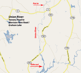
After leaving our bicycles 12 miles to the south on Graham Lake, we put in on a beautiful stretch of river along Tannery Road in Amherst.  The first mile consisted of shallow easy class I rapids.  After passing under the Route 9 bridge, the river slowed and deepened.  Trees exploding in spring green crowded the banks.  We would not see a house or a road for the next 8 miles. 

According to the guidebook, a century ago, the Union was a hub of industry with sawmills and tanneries crowding its banks and timber from log drives clogging the river itself.  Today it is pristine, woodsy, and wild in appearance.  We saw huge snapping turtles napping on rocks.  Eagles swooped low overhead.

Above Mariaville Falls, the river quickened and we heard the rush of water below. We portaged along a rough trail on the right bank and put in just below.  The next quarter mile was punctuated by three class III  ledge drops and a maze of rocks. The low water level and relatively weak current allowed us to scout and learn this tricky section of river at a manageable pace.

Below the ledge drops, the river again slows and deepens, with just a few more sections of easy whitewater.

The river gradually widens into man-made Graham Lake, which still provides evidence of its pre-lake days in terms of the large tree trunks still protruding from the surface.  There is an option to take out at Goodwin Bridge (Route 181), but we continued several miles south, to just past the confluence with the East Branch, to the Morrison Road boat launch.

Notes:  Our trip on the Union was following a period of several weeks without significant rain.  In my estimation, this section of the Union should be runable any time the Ducktrap  gauge reads at or above 2 feet and 10 cfs, as those were the readings on the day we paddled it.

A possible side trip is to paddle up Union River East Branch several miles to falls.  Another section of interest is north of our put-in in Amherst.  After return to launch site, we walked up the River Road to investigate the section north of Tannery Road.  At this level, it was rocky, gorgeous, and too low to run, but it would be a lot of fun with more water.  We also left the section south of Graham Lake for another time.  The annual Union River Race, featuring this section from the Graham Lake dam to the Ellsworth town boat ramp, is upcoming on June 12th.