Categories
Acadia Deer Isle Island Camping Maine islands sea kayaking wilderness paddling

From Ear to Ear: Kayaking Around Isle au Haut

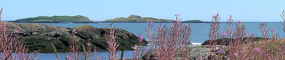
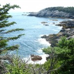
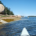
The southern tip of Isle au Haut, between the rocky islets of Eastern and Western Ear, is an otherworldly place of rock, ocean, and sky.   Along with the southern shores of Monhegan, Matinicus, Schoodic, and Great Wass, it is among the most exposed places on the Maine coast.  Kayaking this  remote stretch of coastline is not for the untrained or faint-hearted.

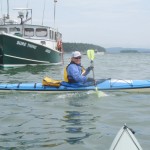
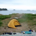
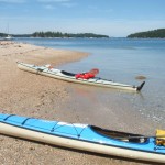
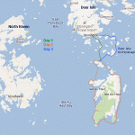
Sea conditions last Saturday (July 30) were settled enough for us to give it a try, and try we did.  On the day before, we had paddled out of Stonington under grey and somewhat ominous-looking skies. We dodged south around Scott, Green, and St. Helena Islands, seeking protection from the stiff headwind when we could find it.  Steve’s Island, a favorite, was occupied by a group of kayakers, so we pushed another mile across Merchant Row to Harbor Island, a BPL Island that is also part of the  Maine Island Trail, where we set up camp for the night. After a night full of rain and wind, we set off the next morning for a 20-mile circumnavigation of Isle au Haut.

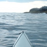
As we paddled south between Burnt Island and Isle au Haut, the fog thinned, the wind eased, and our spirits lifted. The forecasted day of blue skies and light and variable winds seemed to be materializing after all. The winds from the night before were still present in the form of a storm swell that rhythmically rolled in on us from the east.

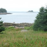
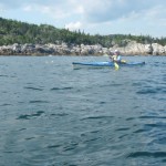
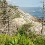
The eastern coastline of Isle au Haut is cliff-lined, rocky, and varied. Well-maintained homes and estates are interspersed along its shores. A procession of ledges and islands line the horizon to the east. These ledges and islands provided welcome protection from the storm swell. As we neared the high cliffs of Eastern Head, swells were converging from two directions —  from the southeast and the southwest — making for confused sea conditions and difficult paddling.

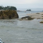
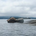
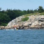
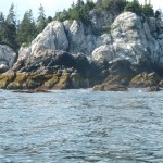
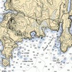
We shot the passage between Eastern Head and Eastern Ear.  Swells whose crests rose  above our heads raced toward us.   Powered by adrenaline, we dug our paddles in and pushed up over the wave crests.   With0ut a doubt, rounding the southern part of Eastern Ear was the most challenging part of the trip.

The seas there were steep-sided, confused, and — counting the refracting waves off the cliffs — now coming from three directions at once. Occasional guillemots marked the water. Occasional lobster boats marked the horizon. Other than that, it was just the two of us, the distant cliffs, and the big sea. Out there, in that wild and foreign environment, the smell of the sea sharp in your nose, the sunlight bright in your eyes, and the swells lifting under you, the very planet seems to palpitate, to hum, and to roar.  Your senses are so wide awake, it is as if you can hear the earth’s heartbeat — and your own heartbeat too.

The southern coast of Isle au Haut

We stayed far offshore to minimize the effects of the refracting waves and paddled steadily across Head Harbor, looking for a beach where we might land or a shoreline where we might get some relief from the waves. By this time, the seas seemed less dangerous, but paddling still required our full attention.  A moment of inattention and a capsize in these cold waters was not something we wanted to deal with.

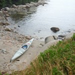
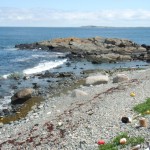
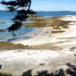
At last, we made our way west-northwest into a somewhat protected cove and landed on a rough cobbled beach.

After lunch and a short hike along the shoreline cliffs, we launched our kayaks and paddled around Western Head. By then, the winds had calmed and the storm swell had diminished. The waves out of the southwest were still large enough to keep us from getting too close to the cliffs. The tide was too low to allow us to shoot the passage between Western Head and Western Ear, so we rounded the ear and turned north into progressively calmer conditions.

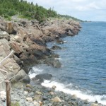
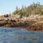
The afternoon light dramatically highlighted the cliffs of the wild shoreline north of Western Ear.  We paddled on happily, feeling assured that the most  difficult conditions of the day were behind us. The sky was blue; the sun was friendly and warm. We loitered among the ledges, watching seabirds, taking photos, and gazing at the cliffs.

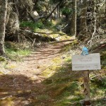
We paddled into Duck Harbor to replenish our water bottles and quickly check out the campground, which I had not visited in several years.

As we moved north from Duck Harbor, we felt both a sense of haste (the day was waning) and leisure (the light was beautiful, the water was calm and increasingly glassy).

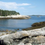
We crossed past the western edge of Kimball Island, paddled east along Kimball Head, and then swung north toward the southern shoreline of Merchant Island. The subtle “huff” of a harbor porpoise is something I heard several times without being able to confirm it. And then we started to see them, repeatedly breaching the quiet water as they worked the ledges for fish. We spent a entranced half an hour moving among the breaching porpoises while they moved around us.

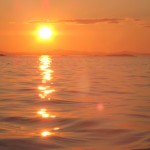
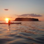
By now the sun was nearing the horizon. It was time to make a push for our campsite on Harbor Island. We rounded the western shore of Merchant, paused to watch the sunset, and then returned, tired, hungry, and happy to our campsite.

Resources:
NPS.org:  Duck Harbor Campground
Mountainzone.com:  Western Head and Cliff Trails
IsleauHaut.com:  Isle au Haut Boat Services
Sea Kayak Stonington:  Around Isle au Haut
Isleauhaut.org:  Isle au Haut Facts

Categories
Maine rivers whitewater wilderness paddling

Cruisin’ the Union: Kayaking the West Branch of the Union River

Great Pond to Amherst, 11 miles

Story has it that the Union River takes  its name from the fact that when the area was surveyed by Samuel Livermore  in the late 1700’s, the river ran right down the middle of twelve newly formed towns.

Nowadays, the upper part of the Union is in the middle of nowhere — and that is just fine with us.

The West Branch of the Union, north of the Airline Road, is billed as Hancock County’s “finest” whitewater run.  We ran it last Saturday for the first time, and it didn’t disappoint.

After a 50 mile drive from Belfast to Amherst via Bucksport and Dedham, we pulled over alongside Tannery Falls (just off the Tannery Loop) and unloaded our bicycles, which we would use later for our return to the put in.  We took a close look at the falls, which though rated “only” a Class III looked fairly gnarly.  Would we run the falls or take out above them?  We reserved that decision for later.   According to the Zip Kellogg’s canoeing guide, if exposed dry rock is visible at Tannery Falls, the river is  too low to run.  If the falls have the appearance of a raging river, it advises, “Don’t try to paddle the river.”  The level looked closer to raging than to dry, but “raging” — we decided —  is somewhat  a matter of perspective.

We drove 12 miles north to Great Pond via Aurora and the Great Pond Road.  After passing through the tiny village of Great Pond, the road turns steeply downhill to the Great Pond Recreation area (formerly Dow Pines), a military-owned campground (open year year; includes cabins and yurts as well as tent sites) that allows public use of their beach and boat launch.  The 375-acre recreation area borders the entire southern edge of Great Pond and also extends south along the western shore of the Union River.

We launched our kayaks from the sandy beach and headed south through  a bay that gradually narrows to the mouth of the river.  Great Pond is largely wild and undeveloped.  Kellogg comments that it is particularly beautiful in the fall, as the the pond is in the center of a bowl of hills and the surrounding slopes have plenty of hardwoods.

Although some sections of the river are not far from roads, The West Branch of the Union provides a sense of wilderness and seclusion.  We sighted no other paddlers, and only a few fishermen during our 11 mile river journey.  The area is rife with wildlife, however.  Hundreds of ducks as well as hawks, deer, turtles, blue heron, cormorants, beaver, and wild turkeys were among the wildlife we encountered.

The paddling was outstanding.  The river is larger and has stronger currents than most of our midcoast rivers.  That plus the seclusion and our unfamiliarity with the river made us a bit conservative.  The river has sections of flatwater, frequent stretches of rips and easy rapids, and a few stretches of  challenging whitewater (strong currents and decent sized waves).  Most notable are the drops.  The West Branch has multiple  small pitches of a few feet in height.  It also has four larger ones, with names like “Hell Gate” and “Captains Roll.”  Kellogg recommends scouting these drops and we emphatically  concur.  

The importance of scouting was reinforced by our experience at one of the earlier, easier drops. Without scouting it beforehand, we lined up to take the drop at Bog Dam rapids “right of center,” just as the guidebook suggested. However, immediately after taking the drop, I was spun and nearly capsized by a mossy green sleeper rock. Leslie, who had been following close behind, backpaddled to avoid my boat, never saw the rock, had her kayak pushed far up onto it, and was spun before finally capsizing. (See all the action in the video below).

Partly due to the time factor (it often takes longer to scout and then go back upriver and run a rapid than to simply portage it), we opted for short portages around the three major drops and took out above the fourth.  This was a recon mission — and for that day at least, just being in the vicinity of those falls provided plenty of adrenalin.

Those pitches are not easy to get out of your head.  I’ve been seeing Hell Gate in my dreams and am itching to head back up there and give it a try.

Categories
books about paddling paddling whitewater wilderness paddling

News Flash: Map & Territory Not Same

Three men dip their paddles into the calm waters of the remote lake and move their canoe up a relatively small inlet.  The year is 1903.  The lake is Grand Lake, a gateway into the unmapped and untraveled wilderness of Labrador.  Their plan is to canoe and portage their way 600 miles west and north to Northwest Post on the Hudson Bay, a heretofore unattempted journey.  They do not realize it, of course, but a mere 2 days and 40 miles into their trip, they are making the journey’s most pivotal decision — one that will lead beyond failure to disaster — and for one of them, death by starvation.

Great Heart:  History of a Labrador Adventure by Davidson and Rugge is an account of this journey, as well as of two subsequent journeys through the wild interior of Labrador by canoe.

One thing that strikes me is their decision to head upriver from the inlet without more fully exploring the northern end of the lake, which in fact has three other major inlets.   One of these is the Naskapi, the river they had intended to take.  But it was approaching mid-July in the short Labrador summer, and their journey had already been delayed by several weeks.  The river they had chosen seemed to fit their  map and the vague descriptions from local trappers well enough.  In the next few days, as they paddled farther, the river became unexpectedly shallow, steep, and rocky, forcing frequent portages.

Had circumstances been different, they might have re-thought their route.  Instead, they continued on for 60 days and 150 miles through an impossible landscape of steep hills, wide swamps, and thick forests.  In mid-September, after almost uncountable miles of portaging their heavy gear, they spent several days windbound on a lakeshore and finally turned back.  By this time, their food supplies were exhausted, the rough country had torn their clothing to shreds, and they were dangerously thin from physical exertion and a lean diet. Temperatures were dropping;  game and fish were more scarce.  Their retreat became a race against winter and starvation.  Two of the men managed to make their way back to the starting point.  The third, Leonidas Hubbard, the leader of the expedition, died of a combination of starvation and (likely) hypothermia.

The title of this post intends no disrespect toward members of the Hubbard Expedition.  The mistake they made could have been made by any of us.  The information they had told of a river leading out of the northern end of Grand Lake.  The first river they came to was that river — this was the conclusion they leapt to.  The maps of the time were made up largely of blank spaces when it came to interior Labrador.  When the map did not conform to the territory they saw in front of them, they mentally willed the territory to conform to the map.

Their story has lessons for all of us who venture into the unknown, whether it be taking a back road to cut across town, guessing left at a fork in a hiking trail, or guessing right at a confluence of two rivers.  Their refusal to turn back, despite mounting evidence that they had taken a “wrong turn” followed stages many of us are familiar with.

First, there is absolute belief that we have chosen the correct route.  During this stage, any signs to the contrary are ignored.  If the map has led us to expect a river and we find  a stream, we stretch our mental construct such that it becomes a “small river” and continue.  In the second stage, our denial deepens.  We begin to have doubts, but we keep on, telling ourselves if we go just a little farther, the landmarks we were anticipating will appear, and the visible landscape will begin to conform more closely with our expectations.  Stage 3 involves accepting that we probably have taken a wrong turn.  Not wanting to retreat, we bargain.  Just go a little farther, we coach ourselves, and we will have more complete proof that we are in the wrong.  Stage 4 involves certainty.  We know we are wrong.  But we have come so far already that turning back has a significant cost.  Better to keep going and hope for a stroke of luck.  Maybe we will yet come out of this better than we have a right to hope.

Most of us have been there.  Most of us will be there again.  In this era of Google Earth, it is more tempting than ever to think that map and territory are one in the same.  The map is not a physical thing though; it is a mental construct.  It is what we can hold in our heads.  The territory is something altogether different.  And that is why we go there.  We go to have our preconceptions shattered.  We go to have better maps.

Great Heart is a story about human stubbornness; it is also a tale of ambition and courage.  Most of us who seek adventure in the outdoors will be able to see ourselves making the same decisions made by these men, and that is part of what makes this journey so gripping.

Resources:
Wildernesscanoe.org has information and links on the 1903 Hubbard Expedition as well as on the 2003 Centennial Expedition.  Maps of Labrador showing the routes of various expeditions are at Basicoutdoors.com