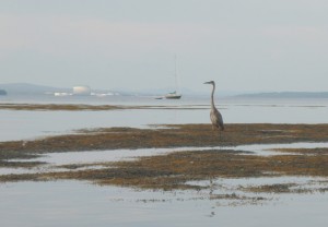
The sparkling, ever-changing waters of Penobscot Bay are a big part of what drew me to the Midcoast. Lots of people can say the same.
My early experiences of the bay were from shore: Holbrook Island, Fort Point, Sears Island, Moose Point, and the Belfast waterfront all provided unique outlooks on the bay. And then I started kayaking, and new worlds of possibility opened up.
The Muscle Ridge Islands, Sheep, and Monroe, Lime and Lasell, Mark Island and Robinson Rock, Islesboro, Flat, Seal, and Ram, Turtle Head, Sears Island, Butter, Great Spruce, Hardhead, and Eagle — these are just a few of the places that have become as familiar as good friends. I feel extremely privileged to have spent the better part or the last fifteen summers paddling — and leading kayak trips — along miles and miles of shoreline and out to the no-two-alike islands of our world-renowned Penobscot Bay.
People do come from all over the world to visit our bay. And, although they take lodging in our towns and spend money in our shops, make no mistake, it is the bay they come for. They come for its beauty. The come for its uniqueness. They come for its quiet.
Water Walker Sea Kayak, LLC is just one among scores of businesses from Port Clyde to Stonington — kayak outfitters, sailing charters, tour boats, fishing charters, water taxis — that get people out on the water — and help keep our hotels and restaurants full.
The way the bay supports our economy can be likened to a three-legged stool. Recreation is one leg. Fishing is another. Both are highly dependent on the continued health of the bay — the health of the web of organisms, from sea ducks to seals to starfish, that call the bay their home.
The third leg of the stool, the shipping industry, has thus far been able to coexist remarkably well with recreation and fishing.
At present, the three legs of the stool are in a marvelous but somewhat delicate state of balance. Leaning on any leg at the expense of the others could tip the balance to the point that life as we know it will go crashing down.

The proposed propane tank in Searsport, the related public safety concerns, the requisite harbor dredging, the introduction of supership traffic to the bay, and the increase of truck traffic to Route 1 — together these have potential to tip the balance toward industry by irreparably harming both fishing and tourism to the point that those industries all but disappear.
There is lots we don’t know about how the tank would affect Searsport and the Midcoast. There is lots we don’t know about how the tank and its attendant superships would affect other economic activities on the bay. There is lots we don’t know about how much area property values might decrease.
We do know that ships would be significantly larger than anything that currently visits Searsport — and that each would arrive with its own moving security zone. We know that the proposed tank would be significantly larger than the existing tanks at Mack Point. We know that the tank would be visible, by land and by sea, from hundreds of vantage points for miles and miles away.
For tourists, the way a town presents itself visually makes the difference between whether they stop and visit or drive on by. Searsport can certainly do better than become known as “the town with a tank in it.”
We know that in an area where tourism and residential real estate make up a huge portion of the economy, perception IS reality — and that, if people perceive an area is undesirable because of visual pollution and hazardous materials, well, then, it is.
We know that when they reach Augusta, tourists choose between continuing north via Route 3, Belfast, Searsport, and Bucksport or staying on the interstate until they reach Bangor.
We know that for Penobscot Bay fishermen the line between thriving and not surviving is a fine line indeed. We know that recreation on the bay has huge yet untapped potential.
We know that the proposed tank will create twelve jobs. Twelve. We know that some in Searsport are already trying to sell their houses — for fear of the tank. We know that the tank issue has threatened to drive a wedge through that community — and that saying hello to DCP Midstream will result in saying goodbye to others.
We know that the pristine beauty of our bay is a treasure that will only become a more valuable and more sought after resource as time goes on. We know we can say, “No,” this once — and there will be plenty of other, more appropriate and less risky opportunities for economic development in our future.