Categories
Belfast maine Penobscot Bay Uncategorized

Tank as Tipping Point: A View from the Bay

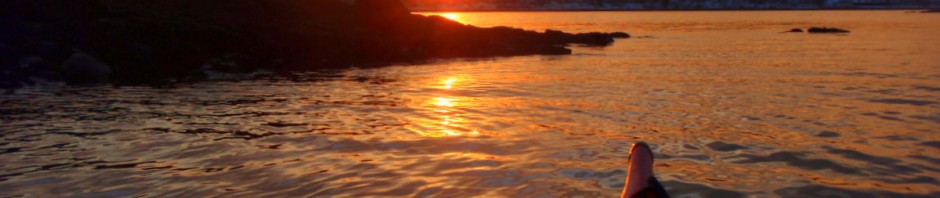
The sparkling, ever-changing waters of Penobscot Bay are a big part of what drew me to the Midcoast. Lots of people can say the same.

My early experiences of the bay were from shore:  Holbrook Island, Fort Point, Sears Island, Moose Point, and the Belfast waterfront all provided unique outlooks on the bay. And then I started kayaking, and new worlds of possibility opened up.

The Muscle Ridge Islands, Sheep, and Monroe, Lime and Lasell, Mark Island and Robinson Rock, Islesboro, Flat, Seal, and Ram, Turtle Head, Sears Island, Butter, Great Spruce, Hardhead, and Eagle — these are just a few of the places that have become as familiar as good friends.  I feel extremely privileged to have spent the better part or the last fifteen summers paddling — and leading kayak trips — along miles and miles of shoreline and out to the no-two-alike islands of our world-renowned Penobscot Bay.

People do come from all over the world to visit our bay.  And, although they take lodging in our towns and spend money in our shops, make no mistake, it is the bay they come for.  They come for its beauty.  The come for its uniqueness.  They come for its quiet.

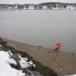
Water Walker Sea Kayak, LLC is just one among scores of businesses from Port Clyde to Stonington — kayak outfitters, sailing charters, tour boats, fishing charters, water taxis —  that get people out on the water — and help keep our hotels and restaurants full.

The way the bay supports our economy can be likened to a three-legged stool.  Recreation is one leg.  Fishing is another.   Both are  highly dependent on the continued health of the bay — the health of the web of organisms, from sea ducks to seals to starfish, that call the bay their home.

The third leg of the stool, the shipping industry, has thus far been able to coexist remarkably well with recreation and fishing.

At present, the three legs of the stool are in a marvelous but somewhat delicate state of balance.  Leaning on any leg at the expense of the others could tip the balance to the point that life as we know it will go crashing down.

This photo approximates the view of the proposed 137-foot propane tank as it would appear, when viewed from the the area near the mouth of the Little River in Belfast. The tank is to scale with the existing tanks but would be situated further back from the shoreline. The blue heron appears as it did in real life.

The proposed propane tank in Searsport, the related public safety concerns, the requisite harbor dredging, the introduction of supership traffic to the bay, and the increase of truck traffic to Route 1 — together these have potential to tip the balance toward industry by irreparably harming both fishing and tourism to the point that those industries all but disappear.

There is lots we don’t know about how the tank would affect Searsport and the Midcoast. There is lots we don’t know about how the tank and its attendant superships would affect other economic activities on the bay.  There is lots we don’t know about how much area property values might decrease.

We do know that ships would be significantly larger than anything that currently visits Searsport — and that each would arrive with its own moving security zone.  We know that the proposed tank would be significantly larger than the existing tanks at Mack Point.  We know that the tank would be visible, by land and by sea, from hundreds of vantage points for miles and miles away.

For tourists, the way a town presents itself visually makes the difference between whether they stop and visit or drive on by. Searsport can certainly do better than become known as “the town with a tank in it.”

We know that in an area where tourism and residential real estate make up a huge portion of the economy, perception IS reality — and that, if people perceive an area is undesirable because of visual pollution and hazardous materials, well, then, it is.

We know that when they reach Augusta, tourists choose between continuing north via Route 3, Belfast, Searsport, and Bucksport or staying on the interstate until they reach Bangor.

We know that for Penobscot Bay fishermen the line between thriving and not surviving is a fine line indeed.  We know that recreation on the bay has huge yet untapped potential.

We know that the proposed tank will create twelve jobs.  Twelve.  We know that some in Searsport are already trying to sell their houses — for fear of the tank.  We know that the tank issue has threatened to drive a wedge through that community — and that saying hello to DCP Midstream will result in saying goodbye to others.

We know that the pristine beauty of our bay is a treasure that will only become a more valuable and more sought after resource as time goes on.  We know we can say, “No,” this once — and there will be plenty of other, more appropriate and less risky opportunities for economic development in our future.

Categories
Belfast kayaking paddling Penobscot Bay sea kayaking

Paddling, Premonitions, & Possibilities

“Wandering re-establishes the original harmony which once existed between man and the universe.”  –Anatole France

The once billowy snow has hardened into something that more resembles rock.  The noonday perch of the sun is beginning to show some ambition.  Daylight length is up to 10 hours and 49 minutes, and “length of visible light” is up to a democratic  11 hours and 48 minutes. Traveling through the woods on warm afternoons,  at intervals where spring streams will later be, I hear rivulets of water gurgling under the snow.

This week at least, the paddle leans in front of the skis in the corner of the mudroom.  The more insular world of woodstove and woodpile and backwoods trails holds its own attractions, but those attractions have paled.  I am looking less for a covering of new snow and more  for days with light winds and ample sunshine — days to get out on the water.

It is important to remember, though, that as the land begins its slow slide from one season to the next, the cold wet mass of the Atlantic acts like a parking brake.  Penobscot Bay water temperatures are now a mere 34 degrees F — 4 degrees colder than  a month ago — and still dropping.

Minnesota Sea Grant provides us with the sobering fact that, without a dry suit or wet suit,  functional survival time in water of such temperature may be less than 15 minutes.  I wear a dry suit.  I go out only on calm days.  I stay close to shore.

I’ve paddled three times in the last ten days after going an uncharacteristic two months  without paddling.  This time of year, paddling out onto Belfast Bay can feel like a lonely act.  But it also feels like joining something.  Currents bring flotsam and jetsam from afar.  Sea ducks whirl about.  Seals move like hidden fleets of submarines beneath the waves.  The sky is big and the bay mirrors its color.   The sun is doubled and re-doubled again and again on the surface of the water.  Belfast Bay widens to Penobscot Bay which widens to the Gulf of Maine which widens to the Atlantic. Possibilities for wandering are limited only by time and imagination.

One who appears short of neither time nor imagination is Aleksander Doba, a 64 year old paddler from Poland, who recently — with very little media fanfare — completed an unsupported solo kayak journey from Africa to South America.  It was only the 4th successful kayak crossing of the Atlantic and the first “continent to continent” crossing.  Doba’s 3,345 mile crossing took him 99 days, also making it the longest open water journey in a kayak.  Canoe & Kayak Magazine has posted an online article detailing the expedition that also includes photos of Doba’s specially designed 23′ x 36″ kayak.

Doba is ashore right now, but he wants to keep paddling.  The United States is next on his list.  Maybe, one day in the future, we’ll see him riding the tide into Belfast Harbor at sunset.

Categories
Camden kayaking maine Maine islands paddling Penobscot Bay

Reaching for Robinson Rock: A Kayak Trip out of Camden, Maine

Halfway between Camden and North Haven is a rock that serves as a landmark and hazard for boaters.  On the chart, it appears as a squiggle – and it’s not really much more than that.  It would never  do for human habitation.  The biggest storms of winter nearly wash over it.  You could never grow anything there or build anything permanent.   It’s just a waypoint on the way to somewhere else.

It likely gets only a handful of visitors each year, if that.  It does have unsurpassed views of the Camden Hills and Penobscot Bay.   It’s a place that looks little different than it did 100 years ago – or 1,000.  It’s not even part of the Maine Island trail.  The guidebooks don’t touch it, as if it is too small and inconsequential to mention.  Google knows about it, but it doesn’t know much.  No evidence of humans or of human visits is easily found.  If you arrive there, it is probably by accident.

1.9 acre Robinson Rock is 4 nautical miles southeast of Camden Harbor and a little less than a mile south of Mark Island.  It has a couple of rough gravel beaches tucked between rocky headlands.  It has tide pools more than adequate for an afternoon’s contemplation.  It has a soft peaty soils and a rough green meadow of raspberry, burdock, and wild rose.  Harbor seals, sea gulls, cormorants, and nesting black guillemots call it (and its surrounding ledges) home.  Eagles, who frequently nest on nearby Mark Island, can be seen overhead.  Far off, the Camden Hills rise up like a distant country.  It’s a wilder place than we are accustomed to seeing this far up the bay.  The mighty Atlantic comes to call – and has left its mark – on the bedrock and in the beaches..  It feels more akin to the open ocean  than it does to most of the other islands of our bay, which tend to be wooded and garden-like in comparison.

As an IFW (Inland Fisheries and Wildlife) bird nesting island, it is closed to the public during nesting season, which extends from April 1 to the end of August.  Given the remoteness from the mainland, the exposure to  open water, and the inadvisability of embarking on long crossings once ocean temperatures drop, this leaves only a short window for visits.  Finding a day in September where conditions permit  a crossing is not easy.  Combine that with work and household schedules, and pulling off a trip to Robinson Rock is a rare feat and much treasured opportunity.

We had such a day a few weeks ago.  The bay was windless and glassy as we set out of Camden Harbor.  Even so, the wind came up during the day and by the time we headed back across on our return crossing, we had to battle a difficult beam seas during our entire trip.  The wind generally blows north or south (straight up or down) Penobscot Bay, making any east west crossing in a  a kayak dicey – and potentially dangerous.  I do not recommend taking the trip unless you are have been sea kayaking for a number of years, have made shorter crossings (such as Saturday Cove to Islesboro) in a variety of conditions, and are equipped with full safety gear including vhf radio, flares, extra clothing, and at least one partner with whom you have practiced various re-entry rescues.  A tent and a sleeping bag (in case of being stranded on the island due to a change in weather) would not be a bad idea.

If ashore on a fair day in September, with late summer sunlight spilling over the water, the rock , and the beaches, with a salt breeze coming up the bay and the cry of gulls and the boom of surf in the air, you will fully appreciate Robinson Rock is much more than a rock.  If caught up in the spirit of the place, you might even feel for a while that you could abandon all ties to the mainland and just live there like the seals and the guillemots.  But you know that as the nights get cooler and the sunlight wanes, the seals and “guilleys” will leave.  As you know you must.

For those of you out there contemplating a visit, just remember that the trip is difficult and a little risky.  Anyway, you probably have a lawn to mow or firewood to stack.  After all, Robinson Rock is just a rock.  It is four long miles from Camden Harbor, and all that raw beauty is almost too much to bear.

Categories
Downeast Maine Maine islands Penobscot Bay

Guillemots: Clowns of the Sea

Black guillemots would be strong contenders in any competition for “clowns of the sea,” and perhaps even serve as proof that God has a sense of humor. They are a medium-sized black duck with white wing patches — and bright red feet. The inside of the guillemot mouth is bright orange. Legs set far back so they wobble when they walk, kinda like penguins. The habit of repeatedly dipping their heads (and tipping up their hind ends) when nervous. Awkward in flight, they fly low over the water with rapid wingbeats — when they fly at all.

Oh, and it bears repeating, they have red feet, which they trail behind them like oversized clown shoes when the take off. Taking off is difficult for them so they are more likely just to dive underwater to escape a threat. They are much better swimmers than fliers and can stay underwater for up to 2 minutes. They migrate not by flying but by swimming hundreds of miles. Related to puffins, guillemots get a lot less press. Ever hear of a guillemot tour? Guillemots don’t seem to mind the lack of notoriety though. Their motto seems to be: guillemots have more fun!

As part of my “critters of the sea” series, I’m featuring the black guillemot this week. I always enjoy watching these birds as they bob unconcerned on rough seas or go tails up and dive beneath the surface. Along the Maine coast, guillemots are sighted most often in pairs or groups of up to a dozen. They are most common in areas with rocky shorelines and access to open waters. On our kayak tours off Stonington, South Thomaston, and Jonesport, we almost always have numerous black guillemot sightings.

Guillemot (rhymes with spill-a-lot) chicks hatch from eggs laid in rocky burows on offshore islands. According to what I’ve read online from various sources, the chicks grow rapidly and soon enter the sea to evade predators such as gulls. They are one of the most commonly sighted Maine sea ducks — and can be sighted along much of Maine’s coastline during all months of the year. During the winter, at least some of Maine’s summer guillemot population migrates south to Massachusetts. Guillemots are pelagic, meaning they spend most of their lives at sea, coming ashore only to breed, yet they rarely venture far from shore.

The range of guillemots, which are sometimes called “sea pigeons,” is described on the National Audubon Society website:Black Guillemots breed from eastern Canada south to the coast of Maine, then eastward at the fringes of the Arctic across Eurasia, reaching North America in isolated colonies in northern Alaska and the Yukon Territory.”

Nick Schade of Guillemot kayaks describes the behavior of the black guillemot: “When paddling toward a guillemot swimming on the surface, it will quickly duck it’s head into the water, looking to make sure it is safe to dive. It will dive with a quick beat of it’s wings to help it under. If you are close enough you will see the white wing patches flash as it flies through the water. If the bird chooses to fly instead of dive, it will run on the surface of the water until it can lift off. Then, with its red legs trailing out back it will typically circle around you at a distance of 100 ft for a couple revolutions.
If it decides you are no threat, it will land again. Otherwise, it will fly until it reaches a safe distance before landing,”

Information on the Black Guillemot in Alaska and how they are being threatened by reduced sea ice is here.

Resources:

National Audobon Society

University of Maine at Farmington

Wildbird.com

Allaboutbirds.org

Young black guillemot on Robinson ledge off Camden.(Photo by Ray Wirth)

~~~~~~~~~~~~~~~~~~~~~~~~~~~~~~~~~~~~~~~~~~~~~~~~~~~~~~~
Ray Wirth is a Registered Maine Guide and owner of Water Walker Sea Kayak, LLC.

Comments and questions can be sent to ray@touringkayaks.com

Categories
Penobscot Bay sea kayaking

Seals but not on Seal Island. Flat Island Still Flat:


An early season paddling trip to Flat and Seal Islands, off Saturday Cove, Maine.

During the next few weeks, I’ll aim to focus my posts here on some of the critters (winged, on foot, or afloat) that you might expect to encounter if you explore the Maine coast by kayak.

Last week I paddled out to Flat Island and Seal Island from Saturday Cove (Northport, Maine) for this first time this season. The tide was calm and the bay was flat — perfect conditions for sighting seals in the water. Midway on my crossing to Flat Island, I spotted at a distance a cluster of activity. Approaching closer, I found that it was a group of 3 sea gulls as well as several seals that kept resurfacing in that area. Must have been some good fishing in that spot.

As I approached Flat Island and began to circle it, I sighted more seals, both ashore and afloat. I paddled slowly, giving the island a wide berth, so as not to disturb any resting seals. In several instances, seals surfaced near my kayak, popped their heads high out of the water to get a good look at me, and then rather calmly dipped back beneath the surface.

In all, my informal count came to 21 seals on and around Flat Island. (Disclaimer: some seals may have been counted more than once if they followed me as I circled the island). This seems like more than in recent years.

Overall, the Maine harbor seal population is said to be doing very well, having increased from just 4,600 in 1973 to more than 28,000 today. Prior to 1972, harbor seals were hunted due to being a perceived threat to the fishing industry. In the first half of that century, Maine and New England’s harbor and gray seals were nearly hunted to extinction as a result to bounty policies. However, scientific studies have not shown seals to have a negative impact on fish stocks. The Marine Mammal Protection Act of 1972 protects seals and other marine animals from hunting and various forms of harassment.

Harassment of the inadvertent kind is a big issue for boaters as resting seals are often alarmed by the sight of kayaks and will leave their resting spots to go into the water. If this only happens once or twice a day, it probably isn’t much of a problem, but if it happens repeatedly or occurs during pupping season, it adds a lot stress to the seals and can negatively affect their survival.
I’ve wondered about migration of harbor seals, which seems to be a subject of debate. According to at least one source, “our” harbor seals actually have dual residency. Jim Murtagh, states that Maine harbor seals are not Maine residents exclusively, as many of them winter on Long Island Sound and then migrate back up to Maine early each spring to give birth to pups.

Anyone who sights a stranded or injured seal can report it to Allied Whale at College of the Atlantic in Bar Harbor.

Resources:

http://www.marinemammalcenter.org/learning/education/pinnipeds/harborseal.asp

http://en.wikipedia.org/wiki/Harbor_Seal

http://www.mita.org/learn/history/seals


Google Map of Flat Island

http://www.touringkayaks.com/blog2/2008/05/paddling-to-islesboro.html

http://www.paddletrips.net/sealisltrip.htm

Categories
cold water kayaking hypothermia kayak paddling Penobscot Bay

Lessons from Cold Water Boot Camp

While paddling from the Commercial Street Boat Launch to the mouth of Little River the other day, I crossed paths with two other Belfast kayakers who were also out enjoying the brilliant December sunshine. Winter paddling is not for everyone, but IF you have the right equipment, take the right precautions, and maintain a healthy respect for cold water, it can be safe and immensely rewarding.

Skaters and hockey players have begun to venture out onto area lakes and ponds. With the ice-fishing season opening up on January 1st, it seems a good time to review the latest research on the effects of cold water immersion.

The dangers of hypothermia have gotten a lot of press in recent years, and hypothermia is what most people think of first when it comes to cold water immersion. But as the 10-minute Coast Guard video Cold Water Boot Camp shows, hypothermia is only one-third of the challenge of being unexpectedly immersed in cold water.

The first challenge is cold shock (also known as “the gasp reflex”), which lasts for about 1 minute and results in gasping and uncontrolled breathing. Cold shock can severely limit your ability to swim or do anything to rescue yourself. It also can cause you to ingest water into your lungs, especially if you gasp while under the surface or while submerged by a wave.

If you survive the first minute, you will begin to breathe more normally. The second challenge of cold water immersion is cold incapacitation. According to the video, in water temperatures of 45 degrees, you have just 10 minutes of “meaningful movement” before your muscles will be impaired to the point that you may no longer be able to perform simple self-rescue tasks such as swimming, holding onto a rope, hauling yourself up onto the ice, or climbing back into a kayak.

According to the GoMoos site, Penobscot Bay water temperatures are down to 39 degrees. Without doing a lot of complicated math, let’s just say, that doesn’t give you a lot of time.

The third challenge of cold water immersion is loss of functioning due to lowered core body temperature (hypothermia). The video states that in 45 degree water it would only take one hour before you lapse into unconsciousness.

The point the video makes is that due to the effects of cold shock and cold incapacitation, if rescue is not immediately available, you likely would drown before reaching the hypothermia stage — unless you are wearing a life jacket or have some other means of being supported in the water.

If you are paddling, please wear a life jacket and dress for immersion. This means wearing a wet suit or dry suit.

If you are going out on the ice, check the thickness of the ice before doing so. A thickness of 6 inches is suggested for those on foot. Also be aware that ice thicknesses can be highly variable. Going out on the ice with a partner is a good idea. Rope, a whistle, and a cell phone can be useful if a rescue is needed. And if you are at all doubtful about the safety of the ice, it’s not a bad idea to wear a pfd.

Wishing everyone an adventurous and safe 2009!

Categories
Muscle Ridge Penobscot Bay sea kayaking

Taking it Easy on Muscle Ridge: A Kayak Trip out of South Thomaston

When sea kayakers talk about paddling the coast of Maine, they talk about Deer Isle, they talk about Acadia, they talk about Muscongus Bay. Not so often do they talk about the Muscle Ridge Archipelago which, to my mind, offers some of the best paddling on the midcoast.
Advertisement

The Muscle Ridge Archipelago is a wildlife-rich group of islands and ledges on the western end of Penobscot Bay, about 2 miles offshore from South Thomaston. Muscle Ridge was apparently named for the blue mussels which can be found there in great numbers — and not for the pecs of the thousands of workman who quarried granite from those islands in the late 1800’s nor for those of the lobstermen who fish those waters today.

We paddled out of Birch Point Beach State Park (another under-appreciated Maine treasure — link here for map), circled Ash Island, and then headed across the Muscle Ridge Channel toward Otter Island. Early on the 1 mile crossing, we were treated to the site of 4 harbor porpoises surfacing about 50 yards in front of our kayak. This was only the first of several wildlife sightings on the day. We also saw osprey, eagles, eiders, harbor seals, guillemots, cormorants, and three somewhat bemused island sheep.

The wildlife is one thing that keeps bringing me back to Muscle Ridge. An incredible 10 percent of Maine’s seal population is whelped amongst this relatively tiny cluster of islands. Eiders and other ducks can usually be seen by the hundreds, if not thousands.

Once you reach the archipelago, it is possible to paddle in relatively protected waters, but the channel itself often offers challenging conditions including a 1 – 2 knot tidal current, wind, and steep chop, if not swells. Conditions can also change very quickly. For these reasons, paddling out to Muscle Ridge is not recommended for beginners, or for those without adequate safety gear and rescue skills.

Conditions improved as we crossed to the archipelago: the patches of fog moved out and were replaced by blue skies and brilliant sunshine. We paddled alongside High Island with its stacks of squared-off granite as remnants of it’s history as a quarry. Then we continued south around the southern side of Andrews Island, with its high pink granite cliffs and pounding surf.

From there, are route took us west to Yellow Ledge and then back north through the split in Hewitt Island before tracing our way past Flag Island and Bar Island.

We savored the late summer afternoon light and waited as long as we could before turning our kayak north past the Clam Ledges where we sighted dozens more seals. With the sun sinking below the horizon, we recrossed the Muscle Ridge Channel, and then pulled back ashore in the deepening dusk at Birch Point Beach.

Categories
kayak kayaking maine paddling Penobscot Bay

Circumnavigating the Cape: A Kayak Trip Around Cape Jellison

One of the great things about Midcoast Maine is that you can find adventure without going far from home.


A friend and I planned to paddle around Sears Island, but the causeway was closed off due to a chemical spill. Plan B? We had no plan B, but the plan that evolved was to launch from the Stockton Springs boat ramp off the Dock Road on Cape Jellison and paddle out to Squaw Point. The sun was warm, the sky was blue, and the breeze was light. We decided to push on along the Cape to Fort Point.

Squaw Point, at the southwest tip of Cape Jellison, offers one of my favorite views of Penobscot Bay. From there, you look past Sears Island to the Camden Hills. You look across the bay to Turtle Head and Islesboro. You look up the bay toward Castine and Fort Point.

The coastline here is rugged, the weathered cliffs broken in only a few places by rocky beaches. I’ve paddled there when the wind was from the south — and the rebounding waves off the cliffs can create confused seas and challenging paddling conditions. On this day, though, a friendly tailwind and light chop out of the southwest pushed us northeast up the coast toward Fort Point.

At Fort Point, after turning to enjoy the fine view out the bay, we passed the high cliffs and the lighthouse and went ashore at the state park — on a sandy spit just north of the lighthouse.

While we ate lunch and relaxed in the sun, the wind picked up considerably. Soon the bay was full of whitecaps — usually an indication of a wind speed of at least 15 knots.

Rather than retrace our route and face that stiff wind over the 3 mile stretch back to Squaw Point, we decided to paddle northwest past the Fort Point docks and through Fort Point Cove to the narrow part of Cape Jellison where we could then walk the mile or so back to our vehicle. The shoreline here provided protection from the wind — and conditions were calm. We easily completed the paddle and walking legs and got back to Belfast just as it was getting dark.

The total distance of the trip was about 7 miles. Unless you are an experienced paddler in a seaworthy boat, avoid paddling the trip when the wind is out of the south. There is no public access and few good places to go ashore in the 3 miles between Squaw Point and Fort Point.

Categories
Penobscot Bay sea kayaking

We Make the Times!

Paddling Down East From Inn to Inn

Published: New York Times, August 24, 2007

THE tides and wind were against us and the sun was in our eyes as we paddled into the harbor at Rockland, Me. My friend Kira and I emerged from the marina in our life jackets and spray skirts, lugging paddles, nautical charts and clothing across the street to the Old Granite Inn, our shoulders sore and heads aching from two hours of paddling in the heat.

–photo by Herb Swanson for The New York Times

We were so tired we thought about going straight to sleep — but then someone told us about a local restaurant, one of the best in Maine. Within the hour, we were seated at its elegant copper bar, drinking strawberry-and-rhubarb cocktails, mixed with ingredients from the garden out back.

We had paddled a quarter of the way up Penobscot Bay, starting about 60 miles northeast of Portland, because I wanted a sea-kayaking journey on the Maine coast. But I also wanted hot showers and a warm bed. I didn’t mind doing some of the hard work (the paddling), but I didn’t want to do all of it (the cooking). The answer: an inn-to-inn kayaking trip . . . [to read the full article, see Paddling Down East From Inn to Inn, The New York Times.

Categories
Penobscot Bay sea kayaking

Hurricane Island Photo Highlights

1. Sunrise over Camden Harbor: 5:22 AM.
2. Young guillemot on Robinson Rock, south of Mark Island. This guilly was surprised as I was to find the two of us in such close proximity. He seemed to take comfort in thinking that if I didn’t look at me, maybe I wasn’t really there.
3. Seals sleeping in the morning sunlight on the bouldered beach between the ledges of Robinson Rock. As soon as I saw them (well-camoflauged as they are), I backed out of the cove as quietly as I could.
4. Navigation marker at Fiddler ledge, off the western tip of North Haven.


Posted by Picasa