Something happens when you get out on a river, after you are several miles downstream from the put- in, and while you are drifting down through a dense corridor of trees that screens out the surrounding world, especially if the weather is warm, the sunlight is on the water, and you have not paddled this particular section of river before.
You have this sense of not being able to place yourself. You have no idea what is around the next bend. True, if pressed to it, you could point out your rough location on a map. But, by just looking around, you could be almost anywhere. You could even be that younger version of yourself who paddled a similar-looking river years ago. But you’re not. You’re right there, wide awake and looking. Time is something you have forgotten about. You drift onward. You paddle. You drift..
We had some of those moments while paddling the West Branch of the Union River a week ago.
At this time of year, as the river levels drop and temperatures warm, our attention usually shifts to the coast rather than the rivers. However, a weather forecast calling for wind gusts of up to 30 mph last Sunday gave pause to that inclination. It would not be a good day to venture offshore. Paddling any upwind legs along the coast might prove to be daunting. Tragically, as we learned later, this was to be the day that two young women died at sea while kayaking off Peak’s Island in Southern Maine, a reminder that winds over 20 knots add significantly to the risk level for all but the most experienced kayakers.
For the previous two days, forecast in mind, we had studied maps and guidebooks. Waldo County rivers were running low from the lack of rain. But we theorized that the Union River, with it’s large catchment area, would still have adequate water. And we were intrigued with the West Branch of the Union, which we had never paddled, and which is described in Delorme’s Canoeing Guide as “Hancock County’s finest whitewater run.” If the river was too low, we would paddle the northern narrower section of Graham Lake. Since the winds were out of the northwest, we would aim to paddle south — and later bicycle back our starting point.
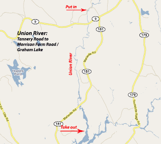
After leaving our bicycles 12 miles to the south on Graham Lake, we put in on a beautiful stretch of river along Tannery Road in Amherst. The first mile consisted of shallow easy class I rapids. After passing under the Route 9 bridge, the river slowed and deepened. Trees exploding in spring green crowded the banks. We would not see a house or a road for the next 8 miles.
According to the guidebook, a century ago, the Union was a hub of industry with sawmills and tanneries crowding its banks and timber from log drives clogging the river itself. Today it is pristine, woodsy, and wild in appearance. We saw huge snapping turtles napping on rocks. Eagles swooped low overhead.
Above Mariaville Falls, the river quickened and we heard the rush of water below. We portaged along a rough trail on the right bank and put in just below. The next quarter mile was punctuated by three class III ledge drops and a maze of rocks. The low water level and relatively weak current allowed us to scout and learn this tricky section of river at a manageable pace.
Below the ledge drops, the river again slows and deepens, with just a few more sections of easy whitewater.
The river gradually widens into man-made Graham Lake, which still provides evidence of its pre-lake days in terms of the large tree trunks still protruding from the surface. There is an option to take out at Goodwin Bridge (Route 181), but we continued several miles south, to just past the confluence with the East Branch, to the Morrison Road boat launch.
Notes: Our trip on the Union was following a period of several weeks without significant rain. In my estimation, this section of the Union should be runable any time the Ducktrap gauge reads at or above 2 feet and 10 cfs, as those were the readings on the day we paddled it.
A possible side trip is to paddle up Union River East Branch several miles to falls. Another section of interest is north of our put-in in Amherst. After return to launch site, we walked up the River Road to investigate the section north of Tannery Road. At this level, it was rocky, gorgeous, and too low to run, but it would be a lot of fun with more water. We also left the section south of Graham Lake for another time. The annual Union River Race, featuring this section from the Graham Lake dam to the Ellsworth town boat ramp, is upcoming on June 12th.
