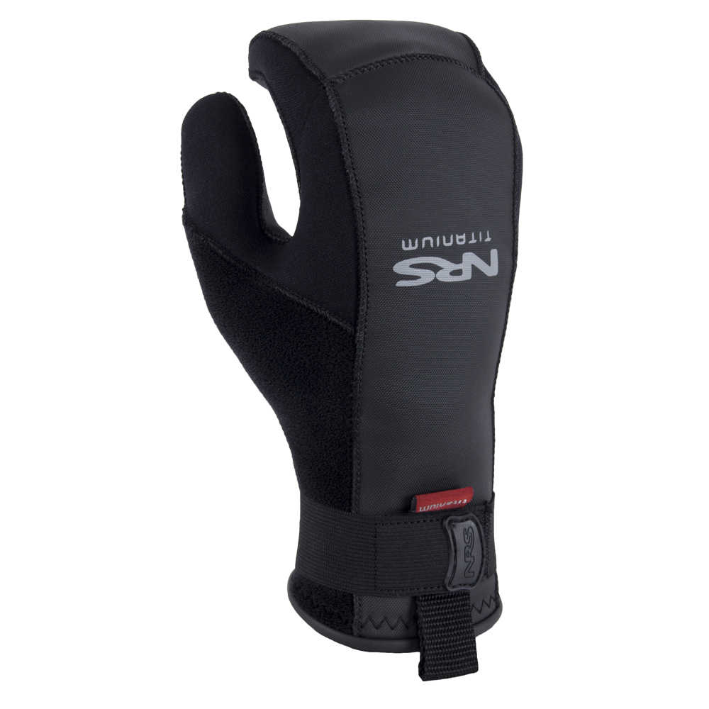
NRS Toaster mitts are not a new product. In fact, they have been around for a long time and are now listed as an NRS closeout, but they are new to me.
I’ve been paddling with Toaster Mitts since November and am thrilled with the level of comfort they bring to my previously wet and cold hands.
Previous to using Toaster Mitts, I was an enthusiastic pogie user. (This is the point in my blog where I may be losing my non-kayaking readers. ‘What’s a pogie?’ They might well ask.) Enthusiastic, yes. After all, pogies are a world above neoprene paddling gloves — both in terms of providing a firm grip on the paddle and maintaining a level of comfort for the hands.
Pogies, as I learned over time, do have a number of shortcomings: (1) once pogies get wet, they are, well, wet — and so are your hands; (2) if you paddle in waves or whitewater, your pogies will get wet; (3) if you paddle with a wing or a Greenland paddle (think no drip rings) your pogies will, see above, get wet; (4) in the event of capsize or when going ashore, once you take your hand off your paddle, your pogies are no longer with you.
The NRS Toaster mitt is a fuzzy-lined neoprene mitten shaped to curve around your paddle shaft and fit snugly around your wrist, and with enough texture to provide a good grip on your paddle. The thickness is just right. Thin enough to provide a feel for the paddle shaft. Thick enough to provide warmth. NRS provides a fit chart and guidelines to measuring your hand so the right fit is assured when ordered online. They come on and off more quickly than a pogie as well.
And they stay dry.
I’ve used mine in temps approaching up to 50 degrees and down into the upper 20’s. I expect I’ll be using them for the first races of the
whitewater series this spring.’
The NRS Toaster Mitt is now on sale for $33.75 at NRS. I like them so much I ordered a second pair. Get them before they are gone!
For most people kayaking is a relaxing and relatively safe sport. However, as can be seen in several recent news stories, kayaking can also be dangerous — and even deadly. One of these news stories recounts a January 9th kayaking accident on Canyon Lake in which two brothers, aged 17 and 25 died. The cause of the deaths is still being investigated. What is known is that the brothers set off from shore at noon and at some point became separated from their kayaks. A a helicopter, boat, and shoreline search commenced when they were reported missing later that afternoon. Their kayaks were found on Saturday evening. However, their bodies were not found until the following morning.
Canyon Lake on a quieter day.
According to Weather Underground, wind speeds near Canyon Lake, which were about 14 mph at 3pm, spiked to 29 mph at 4pm on that afternoon. Although little has yet been reported about the cause of this accident, it is very likely that the two paddlers were unable to make progress and then ultimately capsized when the wind speeds picked up.
One article on the accident reports that the water temperature of the lake was 55 degrees. According to United States Search and Rescue Task Force, most victims will be exhausted or unconscious in less than 2 hours in water of this temperature. Expected survival time is 1 – 6 hours. For victims not wearing life jackets, exhaustion would come more quickly and drowning would occur immediately after the victim becomes unconscious.
People often underestimate the danger of cold water, mistakenly thinking that swimming in 55 degree water might be the same as walking around in 55 degree air. However, as USSRTF points out, “Cold water robs the body’s heat 32 times faster than cold air.” So while an inactive person without extra clothing might start to shiver after an hour or more in 55 degree air, the same person will start to shiver within 2 minutes in 55 degree water.
What can kayakers learn from this tragedy? Wear your life jacket. Be aware of the danger of paddling in water below 60 degrees. Know your limits. Listen to weather forecasts before you go out. Be safe out there!
Despite a winter that brought 100 inches of snow, the 2015 spring whitewater season in midcoast Maine was all too brief. Our annual transition to the bays and islands thus came a little sooner than usual. Based on demand, our summer featured day tours out of Belfast, Rockport, and Camden harbors as well as Stonington. in 2015, for the first time, we offered stand up paddle board rentals and instruction. Our own paddling included racing in the Whitewater Nationals in Old Town/Bangor and sea kayaking forays further Downeast to Cutler, Lubec, and Campobello. Early dawn paddles seeking out whales in the fog has become one of our passions. We plan to offer tours out of Lubec and Campobello in summer 2016. Thanks to all those who joined our tours in 2015. We hope to see you all again next summer!
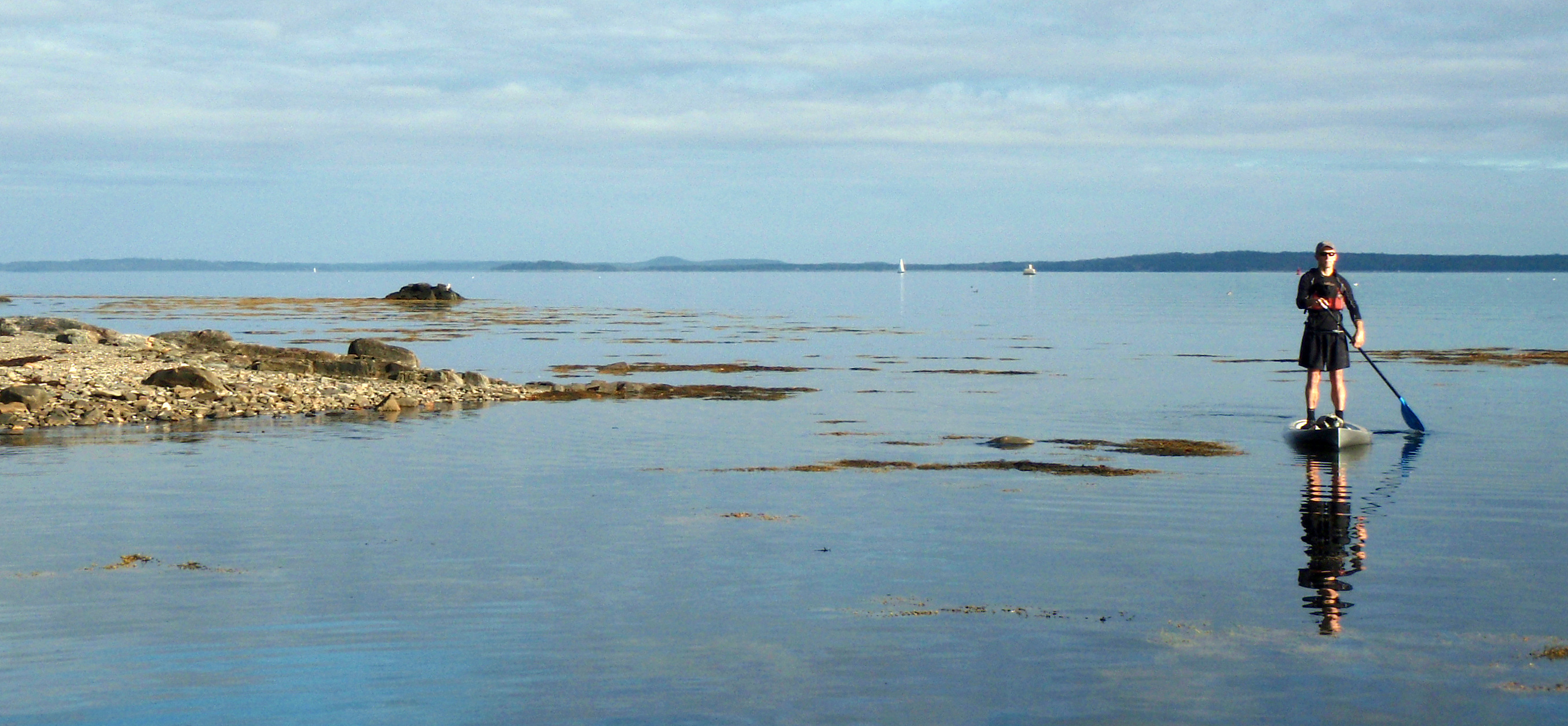
One thing to like best about SUPs is the standing up part. It’s somewhat of a rush to be standing up on top of the water, not unlike the first time I got up on water skis and felt, for a brief few minutes, like I was king of the lake.
You can see more from your 5 – 6 foot vantage point, especially when paddling through a marshland where — if in a kayak — the grasses would obscure your view. Being up higher improves the angle so you can see farther down into the water. Last fall, we spent a magical afternoon on Belfast bay, seeing the sea life on the bottom more clearly than we had ever seen it from a kayak.
Standing up on Belfast Bay.
SUPs being the simple “boards” that they are, they lend themselves to mixing activities and crossing boundaries. Tired of standing up? Sit down or kneel for a few minutes. Want a break from paddling? Lie down and soak in some rays? Getting hot? Go for a swim right off your board. Have a family member, friend, or dog on shore? Have them sit in front of you and take them out for a spin.
Did I mention that one of the best things about SUPs is standing up? Most Americans sit more than we should. Stand up paddle boarding goes even further than kayaking in terms of strengthening core muscles and helps improve your balance.
This may not be true for everyone, but for me, kayaks are destination machines. I get in a kayak and I think about going somewhere. Being on a paddle board is about the experience of being out on the water, not necessarily going anywhere, just playing around, being a kid again.
Our recent shipment of boats from Kayak Distribution includes the Reval Midi PE from Tahe Marine. After reading about the Reval series, we were excited to see, sit in, and test paddle this new-in-2012 design — and we have not been disappointed.
As an entrant into the mid-size performance polyethylene kayak category, the Reval Midi competes favorably with better known designs from VCP, P & H, and Wilderness Systems. The Reval Midi is well-designed, well-built, and thoughtfully outfitted. It fits a wide range of paddler sizes and is just plain fun to paddle.
We’ll be writing more about the Reval Midi as well as its slightly narrower, lower profile sibling — the Reval Mini LC PE — soon! In the meantime, let us know if you’d like to see or test paddle this boat.
The sparkling, ever-changing waters of Penobscot Bay are a big part of what drew me to the Midcoast. Lots of people can say the same.
My early experiences of the bay were from shore: Holbrook Island, Fort Point, Sears Island, Moose Point, and the Belfast waterfront all provided unique outlooks on the bay. And then I started kayaking, and new worlds of possibility opened up.
The Muscle Ridge Islands, Sheep, and Monroe, Lime and Lasell, Mark Island and Robinson Rock, Islesboro, Flat, Seal, and Ram, Turtle Head, Sears Island, Butter, Great Spruce, Hardhead, and Eagle — these are just a few of the places that have become as familiar as good friends. I feel extremely privileged to have spent the better part or the last fifteen summers paddling — and leading kayak trips — along miles and miles of shoreline and out to the no-two-alike islands of our world-renowned Penobscot Bay.
People do come from all over the world to visit our bay. And, although they take lodging in our towns and spend money in our shops, make no mistake, it is the bay they come for. They come for its beauty. The come for its uniqueness. They come for its quiet.
Water Walker Sea Kayak, LLC is just one among scores of businesses from Port Clyde to Stonington — kayak outfitters, sailing charters, tour boats, fishing charters, water taxis — that get people out on the water — and help keep our hotels and restaurants full.
The way the bay supports our economy can be likened to a three-legged stool. Recreation is one leg. Fishing is another. Both are highly dependent on the continued health of the bay — the health of the web of organisms, from sea ducks to seals to starfish, that call the bay their home.
The third leg of the stool, the shipping industry, has thus far been able to coexist remarkably well with recreation and fishing.
At present, the three legs of the stool are in a marvelous but somewhat delicate state of balance. Leaning on any leg at the expense of the others could tip the balance to the point that life as we know it will go crashing down.
This photo approximates the view of the proposed 137-foot propane tank as it would appear, when viewed from the the area near the mouth of the Little River in Belfast. The tank is to scale with the existing tanks but would be situated further back from the shoreline. The blue heron appears as it did in real life.
The proposed propane tank in Searsport, the related public safety concerns, the requisite harbor dredging, the introduction of supership traffic to the bay, and the increase of truck traffic to Route 1 — together these have potential to tip the balance toward industry by irreparably harming both fishing and tourism to the point that those industries all but disappear.
There is lots we don’t know about how the tank would affect Searsport and the Midcoast. There is lots we don’t know about how the tank and its attendant superships would affect other economic activities on the bay. There is lots we don’t know about how much area property values might decrease.
We do know that ships would be significantly larger than anything that currently visits Searsport — and that each would arrive with its own moving security zone. We know that the proposed tank would be significantly larger than the existing tanks at Mack Point. We know that the tank would be visible, by land and by sea, from hundreds of vantage points for miles and miles away.
For tourists, the way a town presents itself visually makes the difference between whether they stop and visit or drive on by. Searsport can certainly do better than become known as “the town with a tank in it.”
We know that in an area where tourism and residential real estate make up a huge portion of the economy, perception IS reality — and that, if people perceive an area is undesirable because of visual pollution and hazardous materials, well, then, it is.
We know that when they reach Augusta, tourists choose between continuing north via Route 3, Belfast, Searsport, and Bucksport or staying on the interstate until they reach Bangor.
We know that for Penobscot Bay fishermen the line between thriving and not surviving is a fine line indeed. We know that recreation on the bay has huge yet untapped potential.
We know that the proposed tank will create twelve jobs. Twelve. We know that some in Searsport are already trying to sell their houses — for fear of the tank. We know that the tank issue has threatened to drive a wedge through that community — and that saying hello to DCP Midstream will result in saying goodbye to others.
We know that the pristine beauty of our bay is a treasure that will only become a more valuable and more sought after resource as time goes on. We know we can say, “No,” this once — and there will be plenty of other, more appropriate and less risky opportunities for economic development in our future.
Over the next few months, we plan to feature some of the places in Maine that we explored last summer in hopes this will inspire our readers to “get out there” in 2013.
We’ll start with Mt. Kineo, located on a peninsula extending from the eastern shore of Moosehead Lake. Mt. Kineo, as well as the 1,000 acre “island: it is situated on, is a Maine landmark long famous to calendars and postcards. Native Americans used it as a gathering place. Thoreau journeyed there and wrote about it. Hundreds of thousands of tourists have visited it, dating back to the 1800’s.
During the summer months, you can take a boat trip out from Rockwood for $10.00, and then hike around the island and climb to the summit.
If you have a kayak — and get the right day, you can do as we did, and paddle out to the island yourself. We launched from the public boat landing in Rockwood, made the one mile crossing to the island, and then, after debating whether to hike or paddle — not enough daylight left for both — we paddled around it. Our chosen route took us in a counter-clockwise direction. It included a short portage over the causeway on the eastern side of island and breathtaking views of the 700 foot rhyolite cliffs that rise directly from the lake. The distance around the island is about 7 miles.
A caution — the crossing can be choppy, and this part of the lake is especially susceptible to sudden changes in weather and wind. Please do not attempt to paddle there unless you are experienced in making crossings, have settled weather, and have a plan for what to do if the weather undergoes unpredicted changes. Winds tend to intensify toward mid-afternoon, so morning is often the safest time for your crossings.
If the Passagassawakeag River is the main artery of Belfast, then the quarter mile stretch between Shepard Road and Route 137 is its secret heart.
Paddlers typically take out above this section, partly due to the dam, partly due to the challenging whitewater that lies below. Those on foot can look downstream from the Shepard Road bridge, from where you will see the first 100 yards. You can also look upstream from Route 137 for about 75 yards. That still leaves a couple hundred yards of secret river, shielded by the sightlines, property lines, trees, and steep terrain — that has been seen by few and traveled by even fewer.
Depending on the time of year and recent rainfall, this section of river appears a boulder-filled stream or a raging, wave-filled torrent. From what I have seen, you’re in for a good ride when water is spilling over the top of the dam. This normally occurs only in the spring or after an especially heavy rain.
When the river is running high, as it was a week ago, the water from the dam passes underneath the Shepard Road bridge and then races southeast down a rocky channel filled with waves. About a hundred yards in, the river splits around a low island. From there, the river swings to the southwest, narrows and quickens. It then enters a gorge that twists south and then southeast. Somewhere in that turn, with a cliff face defining the right bank, the narrowed, churning river simultaneously twines and plunges over a three foot drop. Below this drop is a frothy tumult of waves big as refrigerators.
From there, the river rushes onward toward the Route 137 bridge straightening out and tumbling over numerous rocks as it goes.
Fall whitewater is a special treat. When we go weeks or months without paddling a river, we start breaking out maps and looking for rivers that still have water. It’s great when you don’t have to go anywhere — and the rivers come back to you.
*Paddling this section requires Class III whitewater skills. The waves are large and currents are strong. Maneuvering and bracing skills are needed. Additionally, at this time of year, the water is cold. Please do not paddle this section unless you have proper equipment and experience and have proved yourself on the easier sections of local rivers.
 Pogies, as I learned over time, do have a number of shortcomings: (1) once pogies get wet, they are, well, wet — and so are your hands; (2) if you paddle in waves or whitewater, your pogies will get wet; (3) if you paddle with a wing or a Greenland paddle (think no drip rings) your pogies will, see above, get wet; (4) in the event of capsize or when going ashore, once you take your hand off your paddle, your pogies are no longer with you.