Categories
kayaking kayaks sea kayaking

The Walruses Have Landed — Walrus Kayaks Come to Maine

The Walrus Jaeger in Belfast Harbor at sunset.

One of the best things about owning a small kayak shop (besides scouting out new sections of the Maine coast as potential tour destinations) is having the opportunity to paddle new models of kayaks.

I’ve had that opportunity recently, as we’ve “taken in” a few Walrus Kayaks built by a small company of the same name in Winooski, Vermont.  This is something to like about the kayak industry — that even though you have the relative giants like Current Designs and Old Town, you have plenty of small companies that you might not have heard of building quality. innovative boats.  More than 50 kayak manufacturers are listed in the Canoe & Kayak Annual Boat Book. My guess is that there are at least 50 more small companies that are not listed, Walrus Kayaks being one of them.

It must have taken a bit of chutzpah to start a kayak company in the midst of a bad economy, and — at a time when many other builders are moving their manufacturing operations to China — to insist on building them in small town USA.  It must have taken a bit more chutzpah to choose uncompromising designs and high end materials as central to your business model, but that’s just what Walrus Kayaks did.

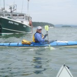
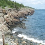
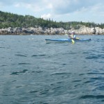
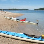
Mark, the Chief Operating Officer of Walrus Kayaks is the guy who most often answers the phone and responds to emails.  He arrived after a snowstorm several weeks ago with a truck loaded with 5 kayaks and a black lab as co-pilot.  We donned dry suits and then drove down to Belfast Harbor to test paddle the boats.  Temperatures were only in the 20’s, but we mostly forget about that as we took turns trying the Griffin and the Jaeger, the first two Walrus models to have gone into production.  (Walrus is now in the process of adding two more models).

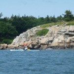
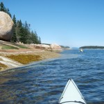
Mark returned to Vermont with just two kayaks on his truck.  Happy ending.  The other three stayed with us.  We’ve been enjoying testing them out in different conditions and locations.

One who doesn’t understand kayaking might find it odd that someone who already has more than 25 kayaks at his disposal could get so excited about a new kayak.  But every kayak has its own personality.  And, ideally, a kayak is something you “wear” more than just sit it.  The Jaeger and Griffin are two exceptionally designed kayaks that have quickly become favorites.

The Jaeger especially has found favor with me.  At 17’4” in length and 22” in beam, the Jaeger fits the mold of a fully capable, full size touring and expedition kayak.  While not the very fastest kayak in our fleet (it’s not a specialty racing boat), the Jaeger is plenty fast enough for fitness paddling and long distance touring and, as a fast kayak, has the distinction of also being a great rough water boat.  The v hull of the Jaeger gives it a lively, playful feel on the water, yet it feels very secure even turned sideways to oncoming seas.

Overall, I’m increasingly feeling that if I was limited to only one boat, the Jaeger would be it — and that’s a pretty high compliment to pay any kayak.

Add to that the excellent and comfortable cockpit and meticulous build quality, and you have one great boat.

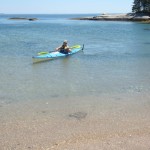
The Griffin, as the name suggests, is a bird of a different feather — though built with the same attention to quality as the Jaeger.  Efficiency, playfulness, a light weight (as little as 31 pounds), easy acceleration, and compact size are some of its best attributes.  Most designers add width when they build a shorter kayak, but with its beam of under 22 inches, the Griffin is a sleek little kayak truly designed with the needs of the smaller paddler in mind.  At the same time, the Griffin is just big enough that a medium size paddler (up to 6 feet and 180 lbs.) can fit in it comfortably.  For this size paddler, the Griffin is a great boat for playing in waves and surf and for day trips.

We’ve begun adding  information about Walrus Kayaks to our website and will continue to do so.  You can read also read more about Walrus Kayaks at www.walruskayaks.com

Categories
maine Maine islands paddling sea kayaking

On the Water in Maine — Best of Summer 2011

As the waters cool, the days shorten, and my schedule transitions from guiding to teaching, my relationship with the water changes too. I look longingly over the bay as I cross the bridge to East Belfast on my morning commute. I hurriedly squeeze in an afternoon paddle between a meeting at school and picking up the kids. Paddling trips are shorter and closer to home. The place where I put in is more likely Belfast Harbor or Pitcher Pond rather than South Thomaston or Stonington. The equinox is a great time to reflect on the summer that was. Days like today give hope that there is a little more of it still left.

Summer started cool, with temperatures on June 24 topping out at 57 degrees. July made us believe in global warming all over again, with 12 days of temps above 80 degrees, and 25 days of at least partial sun. August was more of a mixed bag, but there were still a good number of sunny days and an influx of tourists. Suddenly everyone wanted to get out on the water — today!

Irene brought wind, waves, and rain — and hastened many to pull their boats out of the water. The nice thing about kayaks is that they’re easy to put back in.

Three kayakers lost their lives in Maine waters this summer. One was wearing a life jacket. Two were not. Thousands and thousands of others paddled Maine’s lakes, ponds, and rivers without mishap. Still, an emergency bill is being introduced in the Maine legislature that would make wearing (and not just having) a life jacket a requirement for all those kayaking and canoeing in Maine waters.

I’d rather see an effort to get more paddlers to wear their life jackets through education, not legislation. Do wear your life jacket and be mindful that waters are not as warm as they were a month ago. Paddle safe and enjoy!

Our end-of-summer slideshow has become, for us, a seasonal rite. We hope you enjoy it. A big thank you to all who joined us on our tours. And to those who didn’t, just remember, we can’t put your photo in the slideshow unless you come paddle with us.

Categories
Acadia maine sea kayaking

Dance Floor by the Sea: A Kayak Trip to Baker Island

If you were to view the Baker Island Dance Floor through the lens of a time-lapse camera, you would see that there is a dance going on — one that has taken place over centuries.

Calm bright summer days bring a relative flurry of activity. The dancers most often arrive quietly, in small groups. Mixed among them are those who will only sit. There are, however, usually a few who will dance. They feel the wind, scan the horizon, and listen to the waves breaking on the rocks — as if to internalize the rhythm; and then, although no band is playing, they pantomime a few steps. Sometimes it is a solitary person who rises and stands in the sunlight on that shelf of brilliant pink granite, at the brink of the broad Atlantic, who then steps out an impromptu waltz with the sea.

By the time you reach there, you have crossed  four miles of ocean.  Perhaps the seas have been rough.  Maybe your passage through the Cranberry Islands has been slowed by fog.  After landing your boat on the rocky shore and clambering up through the sea weed zone, you hike for twenty minutes —  up through the meadow, past the old farmhouse, to the lighthouse and then down a narrow trail that at times seems to go nowhere, and then you arrive at this place to which people have been coming for hundreds of years for picnics and dancing.

The dance floor is what you have come for.  Photos don’t do it justice.  You have come a long way for this and have probably been to many granite shorelines in your time, so you come with some skepticism that this will be anything special.  And then the trail opens out to the dance floor and you forget all of that.  It’s a lonely place, an awe-inspiring place, a wild place.  You feel like you are on the edge of something — and you are.  Sky, rock, and sea dwarf all that is human, including human thought.  You get pushed out of yourself.  It’s hard to know what to do.  At the dance floor, the suggested activity is to dance.

Some who arrive there do so as a result of being lured by the brief description under “Unique Natural Features” in the Delorme Atlas.  Some learn about it by reading kayaking or cruising books.  Others come via boat tours out of Northeast Harbor.  Still others come as part of organized groups.  Penobscot Paddles describes their own recent trip to the Baker Island Dance Floor in their blog here.  Ten years ago, a group of 26 social dancers gathered there for a dance that was recorded in a series of photos.   Read about it and view the photos at http://www.cranberryisles.com/baker/dance.html The 2001 event was a re-enactment of sorts of events in the 1800’s, when Cranberry Islanders first began using Baker Island for picnics and dancing.

It wouldn’t surprise me to learn that Native Americans did some dancing there as well.

Baker Island is about four miles south of Mt. Desert Island and is the outermost of the five islands that make up the Cranberry Isles.  Settlers were living on the Cranberry Isles by the early 1760’s.  The island has a 43-foot lighthouse situated at its center that is now  nearly obscured by trees.

Resources:
http://www.cranberryisles.com/baker/dance.html
http://www.acadiamagic.com/BakerIsland.html
http://www.barharborwhales.com/baker-island.php (Baker Island boat tour charter company)

Categories
Acadia Deer Isle Island Camping Maine islands sea kayaking wilderness paddling

From Ear to Ear: Kayaking Around Isle au Haut

The southern tip of Isle au Haut, between the rocky islets of Eastern and Western Ear, is an otherworldly place of rock, ocean, and sky.   Along with the southern shores of Monhegan, Matinicus, Schoodic, and Great Wass, it is among the most exposed places on the Maine coast.  Kayaking this  remote stretch of coastline is not for the untrained or faint-hearted.

Sea conditions last Saturday (July 30) were settled enough for us to give it a try, and try we did.  On the day before, we had paddled out of Stonington under grey and somewhat ominous-looking skies. We dodged south around Scott, Green, and St. Helena Islands, seeking protection from the stiff headwind when we could find it.  Steve’s Island, a favorite, was occupied by a group of kayakers, so we pushed another mile across Merchant Row to Harbor Island, a BPL Island that is also part of the  Maine Island Trail, where we set up camp for the night. After a night full of rain and wind, we set off the next morning for a 20-mile circumnavigation of Isle au Haut.

As we paddled south between Burnt Island and Isle au Haut, the fog thinned, the wind eased, and our spirits lifted. The forecasted day of blue skies and light and variable winds seemed to be materializing after all. The winds from the night before were still present in the form of a storm swell that rhythmically rolled in on us from the east.

The eastern coastline of Isle au Haut is cliff-lined, rocky, and varied. Well-maintained homes and estates are interspersed along its shores. A procession of ledges and islands line the horizon to the east. These ledges and islands provided welcome protection from the storm swell. As we neared the high cliffs of Eastern Head, swells were converging from two directions —  from the southeast and the southwest — making for confused sea conditions and difficult paddling.

We shot the passage between Eastern Head and Eastern Ear.  Swells whose crests rose  above our heads raced toward us.   Powered by adrenaline, we dug our paddles in and pushed up over the wave crests.   With0ut a doubt, rounding the southern part of Eastern Ear was the most challenging part of the trip.

The seas there were steep-sided, confused, and — counting the refracting waves off the cliffs — now coming from three directions at once. Occasional guillemots marked the water. Occasional lobster boats marked the horizon. Other than that, it was just the two of us, the distant cliffs, and the big sea. Out there, in that wild and foreign environment, the smell of the sea sharp in your nose, the sunlight bright in your eyes, and the swells lifting under you, the very planet seems to palpitate, to hum, and to roar.  Your senses are so wide awake, it is as if you can hear the earth’s heartbeat — and your own heartbeat too.

The southern coast of Isle au Haut

We stayed far offshore to minimize the effects of the refracting waves and paddled steadily across Head Harbor, looking for a beach where we might land or a shoreline where we might get some relief from the waves. By this time, the seas seemed less dangerous, but paddling still required our full attention.  A moment of inattention and a capsize in these cold waters was not something we wanted to deal with.

At last, we made our way west-northwest into a somewhat protected cove and landed on a rough cobbled beach.

After lunch and a short hike along the shoreline cliffs, we launched our kayaks and paddled around Western Head. By then, the winds had calmed and the storm swell had diminished. The waves out of the southwest were still large enough to keep us from getting too close to the cliffs. The tide was too low to allow us to shoot the passage between Western Head and Western Ear, so we rounded the ear and turned north into progressively calmer conditions.

The afternoon light dramatically highlighted the cliffs of the wild shoreline north of Western Ear.  We paddled on happily, feeling assured that the most  difficult conditions of the day were behind us. The sky was blue; the sun was friendly and warm. We loitered among the ledges, watching seabirds, taking photos, and gazing at the cliffs.

We paddled into Duck Harbor to replenish our water bottles and quickly check out the campground, which I had not visited in several years.

As we moved north from Duck Harbor, we felt both a sense of haste (the day was waning) and leisure (the light was beautiful, the water was calm and increasingly glassy).

We crossed past the western edge of Kimball Island, paddled east along Kimball Head, and then swung north toward the southern shoreline of Merchant Island. The subtle “huff” of a harbor porpoise is something I heard several times without being able to confirm it. And then we started to see them, repeatedly breaching the quiet water as they worked the ledges for fish. We spent a entranced half an hour moving among the breaching porpoises while they moved around us.

By now the sun was nearing the horizon. It was time to make a push for our campsite on Harbor Island. We rounded the western shore of Merchant, paused to watch the sunset, and then returned, tired, hungry, and happy to our campsite.

Resources:
NPS.org:  Duck Harbor Campground
Mountainzone.com:  Western Head and Cliff Trails
IsleauHaut.com:  Isle au Haut Boat Services
Sea Kayak Stonington:  Around Isle au Haut
Isleauhaut.org:  Isle au Haut Facts

Categories
Acadia cold water kayaking hypothermia sea kayaking

‘Perfect Storm’ of Conditions Leads to Kayaker Death

The kayaker launched from Hancock Point and was found near Hulls Cove. His kayak was found further south near the Porcupine Islands.
In a tragic accident during a honeymoon trip, a kayaker died of accidental drowning in the waters of Frenchman Bay last Sunday.

The purpose of this blog post is not to judge the decisions made by this kayaker or to determine exactly what happened but rather to learn from the incident so that other kayakers can avoid this type of accident in the future.

Sunday, June 19 dawned brilliantly sunny and clear. Visibility was a near perfect 10 miles. The 7:00 a.m. air temperature was listed at 59 degrees. The surface water temperature in Frenchman Bay was 58 degrees.

The young man involved in the incident, Eric Hogan, 28, of Webster, Massachusetts, left the shore of Hancock Point in a sit-on-top kayak, wearing only shorts and a life jacket. The lightness of his attire together with the reported fact that he and his wife were planning to leave their vacation cottage that day, seem to indicate that he only planned a short trip. The perfect visibility must have made the mountains of Acadia appear almost close enough to touch.

Waking up in Belfast that morning, I noted the stiff wind blowing and immediately decided that, for me, it was likely not a paddling day. However, weather records in the Bar Harbor area indicate winds of less than 10 mph at 7:00 a.m. The wind direction was from the WNW, which means if he launched from the east side of Hancock Point, he would have been in the lee of the wind and might not have felt it until he had paddled away from the shore. Even if he launched from the southern end of Hancock Point, he may not have been fully aware of the sea conditions, since — when looking out over the water — it is easy to underestimate waves that are not breaking straight onto the shore.

Low tide on Sunday morning was at 8:08 a.m. The tide is listed as 0.5 feet below “normal,” meaning it was a lower than average tide. At 7:00 AM, the tidal currents when move in and out of Frenchman Bay were nearly slack. Although there would be no clouds or rain that day, that early morning stillness was truly “the calm before the storm.”

By 8:15 a.m., the wind was coming out of the northwest. This may have pushed the kayaker further offshore and made it more difficult for him to return. Average wind speed increased to 12 mph, with gusts up to 21 mph. At shortly after 9:15 a.m., wind gusts of up to 25 mph were recorded in Bar Harbor. By this time the tidal currents that push north up the bay and ultimately west through the Mount Desert Narrows would have begun to increase. When tidal currents are in direct opposition to waves, as they were this day, it results in a rough steep-sided seas. By this time, wave heights at the Eastern Maine Shelf Buoy south of Mount Desert Island had increased from 3.0 to 3.8 feet.

Likely sometime between 9:00 and 11:00 a.m., Eric Hogan’s kayak was capsized and he was not able to get back aboard. Perhaps it had already capsized several times. One feature of sit-on-top kayaks is that unlike standard (“sit-in”) kayaks, they do not take and water and cannot swamp. Following a sit-on-top capsize, a paddler need only flip the kayak upright, clamber back aboard, and resume paddling.

The combination of the wind and wind-blow spray as well as the waves sloshing up onto his kayak undoubtedly started to lower Eric’s body temperature. If he had already capsized one or more times, this would have lowered his body temperature further. When the body gets cold, hands and feet start to lose dexterity. Next, arms and legs begin to lose strength. The mind also slows down. Coordination is lost. Judgement becomes clouded.

On one of the capsizes, Eric may not have been separated from his boat or paddle or both. Or, his arms may no longer have had the strength to pull himself back aboard.

At around 11 a.m., after his wife reported him overdue in returning from his outing, police and emergency response personnel began searching for him. Hogan was unresponsive when the Coast Guard found him floating off Hulls Cove around 1:30 p.m.

For the vast majority of people, kayaking is a relatively low risk sport that enhances health and provides a lot of joy. A study of paddlesport deaths in Maine shows that there were 12 kayaking deaths in the years 2000 – 2007, four of which occurred in ocean waters. However, even one death is too many. Following are some guidelines for reducing the incidence of this type of accident in the future.

1. Wear a life jacket, but also understand its limitations. Although the life jacket does not ensure survival, it does extend survival time when swimming in cold water.
2. Choose a kayak appropriate for the waters you are paddling. For paddling in cold waters, kayaks with enclosed cockpits and sealed bulkheads (provide reserve flotation in case of capsize) are recommended.
3. Leave a written float plan indicating where you are going and when you intend to return.
4. Dress for air AND water temperatures. When paddling the Maine coastline, this may mean wearing a wetsuit or dry suit. When it is summer on the land, it is still spring on the water.
5. Listen to weather forecasts. Winds of more than 12 mph may be too much for beginning paddlers. Winds of more than 18 mph may make conditions unsafe for intermediate paddlers.
6. Be prepared for changes in weather. Dramatic and unexpected weather changes will eventually affect all outdoor adventurers.
7. Study charts. Know the areas you will paddle. Understand the effects of tides and currents. Stay along shorelines as much as possible.
8. Carry a waterproof/submersible VHF radio and/or a cell phone in a waterproof pouch.
9. Practice self-rescue and assisted rescue techniques. Take a class to learn these if you have not done so.
10. Paddle in a group when possible as doing so increases your ability to successfully handle an accident or other unexpected situation.
11. If paddling alone, be more conservative in your decisions regarding all of the above
12. If you are unsure about any of the above, strongly consider going with a guide or more experienced paddler.

*Weather and sea condition data are from Gomoos.org and Wunderground.com

Categories
Downeast Maine Maine islands sea kayaking

Litte Birds, Big Ocean: Paddling with the Puffins of Petit Manan

We rose at dawn and drove to a rocky beach south of Steuben, Maine. After carefully packing our kayaks with safety gear, food, water, and extra clothing, we donned the thick black wetsuits needed to paddle safely in 50 degree waters, launched from the rocky beach, and paddled south along Petit Manan Point. Even as we did so, we monitored the weather on the VHF radio, as this area is renowned for fog and turbulent sea conditions. The mainland slipped away behind us. The ocean yawned wide in front of us. With excitement and trepidation, we continued paddling south for two miles along the shoal that frequently provides some of the diciest sea conditions along the coast of Maine.

Manan means “island out to sea” in Micmac — and, amidst that landscape in which the mainland recedes in all directions, the name seems highly appropriate. The 120 foot spire of Petit Manan lighthouse provides a singular reference point amidst that big sea. We diverted our course to the west to trace the shoreline of adjacent Green island, our eyes alert for what we had come for. But there were only hordes of jeering gulls on the shoreline.

Then we moved onto Petit Manan itself, which is connected to Green, at low tide, by a series of bouldered ledges. On this island which has been called, “one of the most important seabird colonies in Maine,” we saw guillemots, cormorants, eiders, terns, and laughing gulls, but none of the little black and white penguin-cousins we had come for. We saw the puffin blinds used by the U.S. Fish and Wildlife Service naturalists to study and monitor the puffins. We scrutinized the rocky shoreline for sights of puffin nests. We scanned the sky and the water for puffins. And saw none.

By this time, we had circled three-quarters of the way around Green and Petit Manan. On this, our second trip out to the island, we had just about resigned ourselves to not seeing the puffins. Then we rounded the southern tip to the area of Petit Manan reef. Suddenly the sky was alive with Atlantic puffins torpedoing through the air as they circled from the cliffs to our left, swooped out over the the shallow waters of the reef, and then wheeled back toward the lighthouse. These puffin “wheels” I later read are common in puffin areas where gull predation is high.

We rested our paddles on our kayaks, marveling at the sight, and ineptly trying to take photos of the fast-moving birds. Puffin flight is best described as frantic. These foot-tall relatives of penguins have short wings and long stout bodies more adapted to swimming than flying. In flight, their wings, which flap at up to 400 beats per minute, are only a blur. The short wings don’t allow puffins to soar or float in the air. Instead, they dive-bomber through it at speeds of 40 to 50 miles per hour.

Seconds turned to minutes. The sun filtered more brightly through the clouds. Gentle green swells lifted and lowered us as they passed toward the cliffs. We pulled our eyes out of the viewfinders of our cameras and lowered them from the sky to the water. The tidal current had slowly eased us to the north. The water around us was suddenly, magically full of puffins.

Undisturbed by us, seeming to accept our presence, they drifted in groups, preening and puffing and dipping their heads beneath the surface. For a time, we were lost to the human world and joined the puffin one. There, as we drifted, it was possible for a few moments to forget that we were not puffins. To forget that the gentle sea that stirred around us was not our home.

Of Maine’s 4,000 islands and ledges, puffins nest on fewer than ten. Once they leave those nests, they spend up to five years far out at sea before ever returning to land. To say they live on the periphery of human civilization is an understatement. To spend a few minutes among these rare and marvelous birds is a privilege and a gift. Part of that gift is the reminder that beyond the human world lies a much larger one, of which both we and the puffins are just a tiny part.

Resources:
Maine Coastal Islands National Wildlife Refuges
Maine Birding.Net: Atlantic Puffin
Seabird Photography
Bird Fact Sheet: Atlantic Puffin

Categories
Belfast kayaking paddling Penobscot Bay sea kayaking

Paddling, Premonitions, & Possibilities

“Wandering re-establishes the original harmony which once existed between man and the universe.”  –Anatole France

The once billowy snow has hardened into something that more resembles rock.  The noonday perch of the sun is beginning to show some ambition.  Daylight length is up to 10 hours and 49 minutes, and “length of visible light” is up to a democratic  11 hours and 48 minutes. Traveling through the woods on warm afternoons,  at intervals where spring streams will later be, I hear rivulets of water gurgling under the snow.

This week at least, the paddle leans in front of the skis in the corner of the mudroom.  The more insular world of woodstove and woodpile and backwoods trails holds its own attractions, but those attractions have paled.  I am looking less for a covering of new snow and more  for days with light winds and ample sunshine — days to get out on the water.

It is important to remember, though, that as the land begins its slow slide from one season to the next, the cold wet mass of the Atlantic acts like a parking brake.  Penobscot Bay water temperatures are now a mere 34 degrees F — 4 degrees colder than  a month ago — and still dropping.

Minnesota Sea Grant provides us with the sobering fact that, without a dry suit or wet suit,  functional survival time in water of such temperature may be less than 15 minutes.  I wear a dry suit.  I go out only on calm days.  I stay close to shore.

I’ve paddled three times in the last ten days after going an uncharacteristic two months  without paddling.  This time of year, paddling out onto Belfast Bay can feel like a lonely act.  But it also feels like joining something.  Currents bring flotsam and jetsam from afar.  Sea ducks whirl about.  Seals move like hidden fleets of submarines beneath the waves.  The sky is big and the bay mirrors its color.   The sun is doubled and re-doubled again and again on the surface of the water.  Belfast Bay widens to Penobscot Bay which widens to the Gulf of Maine which widens to the Atlantic. Possibilities for wandering are limited only by time and imagination.

One who appears short of neither time nor imagination is Aleksander Doba, a 64 year old paddler from Poland, who recently — with very little media fanfare — completed an unsupported solo kayak journey from Africa to South America.  It was only the 4th successful kayak crossing of the Atlantic and the first “continent to continent” crossing.  Doba’s 3,345 mile crossing took him 99 days, also making it the longest open water journey in a kayak.  Canoe & Kayak Magazine has posted an online article detailing the expedition that also includes photos of Doba’s specially designed 23′ x 36″ kayak.

Doba is ashore right now, but he wants to keep paddling.  The United States is next on his list.  Maybe, one day in the future, we’ll see him riding the tide into Belfast Harbor at sunset.

Categories
Downeast Maine maine Maine islands sea kayaking

Meandering Machias Bay (video)

Yellow Head lies like a sleeping dragon along the western shore of the bay.

What began as a on-water search for the petroglyph sites of Machias Bay morphed into as meandering tour of discovery of the magnificent rock formations of that bay.

After driving south from Machias past the Bucks Harbor Shopping Mall, we parked at unloaded our kayaks at Finn Beach. From there, on that rare calm and fogless morning, we paddled out of Bucks Harbor, past Bar Island, and then southwest along the cliffs to Howard Cove and Jasper Beach.  Along our route, bald eagles soared high into the blue sky above the sea arches and sea caves.

Jasper Beach
is a magnificent 1/2 mile beach made up of multi colored quartz and naturally polished, purplish rhyolite stones.

After returning to the northeast and past Bucks Harbor, we continued on toward the sleeping dragon of Yellow Head and then on to Bare Island, Avery Rock, Salt Island, and Round Island. After exploring Larrabee Cove (still hunting for those elusive petroglyphs), we returned south to Bucks Harbor just in time to get off the water by sunset.

We’ll go back again to search for the 3,000 year old Passamaquoddy petroglyphs, but we were very happy to have found what we did.

(J4WZWGUEEKR2)


~~~~~~~~~~~~~~~~~~~~~~~~~~~~~~~~~~~~~~~~~~~~~~~~~~~~~~~

Ray Wirth is a Registered Maine Guide and owner of Water Walker Sea Kayak, LLC. Comments and questions can be sent to ray@touringkayaks.com

Categories
kayaking sea kayaking

Top Online Resources for Sea Kayakers

For the diehard paddler there are two kinds of weather: weather that is good for paddling and weather that’s good for reading about paddling. The recent cold weather makes this a good time to expand your knowledge and to catch up on the latest controversies, innovations, and new developments in the world of paddling. Here are a few of our favorite kayaking resources:

Paddling.net The Advice, Suggestions, & General Help Forum on this site is a great place to get answers on paddling related questions. Other parts of P-Net (as frequent users have come to call it) also includes kayak reviews, trip reports, articles, photos, and links to manufacturers and outfitters. A great all-around paddling resource. Probably the best place to go if you are one-stop shopping for information on boats or paddling.

Kayakpaddling.net Got a technique question? You can read about it all you want. You can watch all the videos you want. But likely neither will be as helpful as the animations on this site. Holding the paddle, the forward stroke, the eskimo roll, and many other techniques are featured.

Sea Kayaker Magazine
America’s top sea kayaking magazine has a useful website as well. Not all magazine content is available here, but featured articles and the ever-popular kayak reviews are included. Also included are links to kayak clubs, water trails, and an event calendar. Some good reading here.

Atlantic Kayak Tours The online “Expert Center” of this Saugerties, New York outfitter features an extensive set of articles on everything from gear selection to kayak repair to safety, navigation, and technique. The well-written articles are accompanied by photos, diagrams, and animations. A great resource — as useful and as in-depth as most kayak books.

The resources below are of interest to Maine and New England paddlers:

MaCKRO.org The website of the Maine Canoe and Kayak Racing Organization. You don’t have to be a racer to visit the site, join the club, or participate in one of the races. Canoe and kayak racing isn’t so much about racing as it is about developing a cameraderie with other paddlers and appreciating rivers, anyway. A current focus of the club is on promoting youth paddling and encouraging more people to try this sport. Included is a forum where you can get ask questions about paddling, get information on races, find a boat — or sell one.

Maine Island Trail
The Maine Island trail association website provides information about this spectacular 375-mile water trail (America’s first) as well as about the organization. Included are articles about Leave No Trace techniques and boating safety. To travel the trail, you will need to join the club (and thereby receive the island guidebook). The website is your key on how to get information to do just that. Highly recommended for ocean paddlers.

Maine Bureau of Parks and Lands This site includes a searchable database of Maine State Parks and Maine State Public Reserved Lands. A great resource for those wanting to paddle wilderness lakes and ponds. Some of the reserved lands offer free camping.

GoMoos
The Gulf of Maine Ocean Observing System provides real-time data of ocean conditions from buoys off the Maine coast. This site is a great compliment to NOAA forecasts and land-centric weather stations.

Categories
Downeast Maine Great Wass Halifax Jonesport Maine islands Roque Island sea kayaking The Brothers

Journey to the Center of Pulpit Rock: A Sea Kayaking Daytrip Out of Jonesport, Maine

After completing the 100 mile drive from Belfast, Maine, I launched at noon from Kelly Point Campground in Jonesport. I paddled east-southeast past Virgin Island (no virgins sighted), The Nipple (still rising spectacularly from the sea), and the high cliffs of Mark Island. I then swung nearly due east (magnetic) toward the dark cliffs of Pulpit Rock.

Two years ago, on return trip from Halifax Island in the late afternoon light, I watched transfixed as a half-dozen eagles repeatedly tried to raid seagull nests on Pulpit Rock — and were repeatedly outmaneuvered and driven off by the gulls. My plan today was to paddle past Pulpit Rock to The Brothers, a geologically unique and astoundingly photogenic pair of islands I had visited twice before, and then to Halifax Island, one of my favorite islands on the Maine Island Trail.

On the marine chart, Pulpit Rock is a squiggle of dark ink. I hadn’t paddled close to it in the past and didn’t know if it held anything of interest. In my mind, it would be little more than a mile marker on my 6.5 mile paddle to The Brothers.

Who knew Pulpit Rock was not just a ledge but an island? Who knew the island was split in two? Who knew the sea surges in and out the narrow corridor of the split? Who knew you could paddle in there in a small boat — and emerge later unscathed?

I had spent most of the past hour in kind of broad-minded introspection. The big sea and big sky of Downeast Maine never fails to do that for me. I had been mulling (with more curiosity than anxiety) over the life decisions I had made in terms of work and career — and had probably been a bit negligent of my surroundings.

As I paddled along the cliffs of Pulpit Rock and then noticed for the first time that Pulpit Rock was split in the middle and that one could (maybe) paddle into the split, my previous questions — and the kind of mind that cared to ask such questions — were all but forgotten. More than forgotten, they was erased as if they had never been asked.

I took a deep breath and followed the surge of a wave into the passage between the two halves of the island. And then, there I was in a private sea at the center of Pulpit Rock, itself a miniscule crag in this small swath of the Atlantic. The sun high overhead, the cool sea breeze, the dark rock, the birds, the green-blue waves. Was Pulpit Rock whirling around me, or was it just that the waves were whirling my boat? At once, I was right where I was. Right where I was supposed to be. And there could be no questioning of any series of events or life-decisions that had brought me right there, right then.

And that was when I looked up to see the razorbill auks nesting on the cliffs above me. They and the gulls and the cormorants (sequestered in separate areas) seemed to eye me with a mixture of disdain and bemusement. I paddled through to the southern part of the split for a view of the Brothers and then back north and then south again. Waves rhythmically surged through the passageway, rising against the high rock walls. I kept to the center of the channel and made sure to anticipate the waves so that I was not pushed up against the cliffs.

After snapping a last few photos from the cockpit of my kayak, I paddled back out of the split and then continued east toward The Brothers. The wind had increased and sizeable swells rolled in from the southeast. Razorbills swooped low over my kayak. Groups of black guillemots wheeled overhead. Rafts of eiders scuttled away from ledges as I approached them. Sea and sky veritably pulsed with life — I paddled on and felt very much a part of it.

Arriving at West Brother, I swung to the south and had to keep well off the rocky shoreline due to the swells. I paddled east along West Brother and then past the dramatic red cliffs of East Brother. A bit weary by now of paddling in those seas, I was glad to round the northeastern point of East Brother and tuck in along the protected northern shoreline.

After taking a break in the quiet waters between East and West Brother, I headed north between Green Island and Green Ledge. Not quite willing to leave the area yet, I maneuvered my kayak up a channel between rocks and clambered onto the slippery bladder-wrack-coated rock of Green Ledge. Green Ledge proved to be a great vantage point to look south toward The Brothers. I slipped once on the seaweed and fell into a crack between rocks, getting wet to my waist in the process. Sobered by the fall and mindful that even at mid-tide large waves roll right over Green Ledge, I got back into my kayak and paddled north to Halifax Island.

After the wildness and exposure of Pulpit Rock, The Brothers, and Green Ledge, Halifax Island (a BPL island) often seems to be a quiet green oasis — and it seemed so today. The afternoon sun was warm on the rocks, and as I climbed the hill on the western side of the island, I looked for blueberries and songbirds. A few butterflies floated about. Warmed by the sun, the wild roses poured all their scent into the afternoon air.

Islands such as Halifax make me think of the journey of Ulysses and his men — and of the beautiful goddesses they reported seeing on some of those Mediterranean Islands. I’ve concluded that maybe the green islands themselves were the goddesses. Struggling for long over a cold dark sea could lead one to feel that it was so. It’s certainly easy to fall in love with them — and to want never to leave.

After a late lunch (4:00 PM or thereabouts) on Halifax, I paddled west past Anguillia, Double Shot, Great Spruce, and Little Spruce. Large groups of sleepy seals lined the ledges off Anguillia and Double Shot. I then headed east for the 2.5 mile crossing across Chandler Bay to Kelly Point and Jonesport.

Later that evening, I ran a string around a chart and tallied up the days nautical miles as 17. What I saw in those miles I’ll carry with me long after the summer green has faded from those islands.