Categories
Downeast Maine Maine rivers whitewater

Communion on the Union: Kayaking the Union River, West Branch

Something happens when you get out on a river,  after you are several miles downstream from the put- in, and while you are drifting down through a dense corridor of trees that screens out the surrounding world, especially if the weather is warm, the sunlight is on the water, and you have not paddled this particular section of river before.

You have this sense of not being able to place yourself.  You have no idea what is around the next bend.  True, if pressed to it, you could point out your rough location on a map.  But, by just looking around, you could be almost anywhere.  You could even be that younger version of yourself who paddled a similar-looking river years ago.   But you’re not.    You’re right there, wide awake and looking.  Time is something you have forgotten about.  You drift onward.  You paddle.  You drift..

We had some of those moments while paddling the West Branch of the Union River a week ago.

At this time of year, as the river levels drop and temperatures warm, our attention usually shifts to the coast rather than the rivers.  However, a weather forecast calling for wind gusts of up to 30 mph last Sunday gave pause to that inclination.  It would not be a good day to venture offshore.  Paddling any upwind legs along the coast might prove to be daunting.  Tragically, as we learned later, this was to be the day that two young women died at sea while kayaking off Peak’s Island in Southern Maine, a reminder that winds over 20 knots add significantly to the risk level for all but the most experienced kayakers.

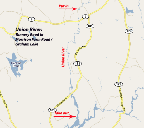
 For the previous two days, forecast in mind, we had studied maps and guidebooks.  Waldo County rivers were running low from the lack of rain.  But we theorized that the Union River, with it’s large catchment area, would still have adequate water.  And we were intrigued with the West Branch of the Union, which we had never paddled, and which is described in Delorme’s Canoeing Guide as “Hancock County’s finest whitewater run.”  If the river was too low, we would paddle the northern narrower section of Graham Lake.  Since the winds were out of the northwest, we would aim to paddle south — and later bicycle back our starting point.

After leaving our bicycles 12 miles to the south on Graham Lake, we put in on a beautiful stretch of river along Tannery Road in Amherst.  The first mile consisted of shallow easy class I rapids.  After passing under the Route 9 bridge, the river slowed and deepened.  Trees exploding in spring green crowded the banks.  We would not see a house or a road for the next 8 miles. 

According to the guidebook, a century ago, the Union was a hub of industry with sawmills and tanneries crowding its banks and timber from log drives clogging the river itself.  Today it is pristine, woodsy, and wild in appearance.  We saw huge snapping turtles napping on rocks.  Eagles swooped low overhead.

Above Mariaville Falls, the river quickened and we heard the rush of water below. We portaged along a rough trail on the right bank and put in just below.  The next quarter mile was punctuated by three class III  ledge drops and a maze of rocks. The low water level and relatively weak current allowed us to scout and learn this tricky section of river at a manageable pace.

Below the ledge drops, the river again slows and deepens, with just a few more sections of easy whitewater.

The river gradually widens into man-made Graham Lake, which still provides evidence of its pre-lake days in terms of the large tree trunks still protruding from the surface.  There is an option to take out at Goodwin Bridge (Route 181), but we continued several miles south, to just past the confluence with the East Branch, to the Morrison Road boat launch.

Notes:  Our trip on the Union was following a period of several weeks without significant rain.  In my estimation, this section of the Union should be runable any time the Ducktrap  gauge reads at or above 2 feet and 10 cfs, as those were the readings on the day we paddled it.

A possible side trip is to paddle up Union River East Branch several miles to falls.  Another section of interest is north of our put-in in Amherst.  After return to launch site, we walked up the River Road to investigate the section north of Tannery Road.  At this level, it was rocky, gorgeous, and too low to run, but it would be a lot of fun with more water.  We also left the section south of Graham Lake for another time.  The annual Union River Race, featuring this section from the Graham Lake dam to the Ellsworth town boat ramp, is upcoming on June 12th.

Categories
Downeast Maine Great Wass

Not a Drop to Drink

Made the trip up to Addison last weekend to close up camp. Boarded up a few windows, secured the tarp that serves as a shed door, unplugged the well pump, drained the pipes and water heater, put antifreeze down the drains, and used a compressor to blow out any remaining water (let’s hope). Propped the fridge door open, pushed the front door shut from the inside (only way to get it securely closed), and made the usual ungraceful exit out the back window.

The annual rite of draining pipes and shutting off the water is for many camp owners fittingly symbolic of the end of summer, requiring resolve, decisiveness, and — often as not — more than a little remorse.

If beings from another planet were to do an anthropological study of New Englanders, they would likely be intrigued by our fixation with water. They would notice that in the summertime, we frequently make long pilgrimages to large bodies of water. Once there, we characteristically shed most of our clothes and recline beside it, swim in it, or go out boating on it. Particularly at dawn and sunset, they would notice groups of us staring out across it, as if in prayer. Near the end of the day great numbers of us gather in eating places that are — you guessed it — beside the water. And then, for good measure, we return to our homes or hotel rooms and douse off with a long shower.

In a land of such water abundance, it is no wonder we take much of our daily water use for granted. According to Drinktap.org the per capita daily use of household water in the US is 69.3 gallons. The biggest chunks of that are for washing clothes and showers.

They say the next world war will be fought over water. That is hard to imagine, living here in the Northeast. It’s easier to imagine when you look at daily per capita water consumption in other countries. In Haiti,for example, that figure is 1.2 gallons.

Ironic water fact of the day: The manufacture of a one liter plastic bottle uses 7 litres of water.

The trip to close up camp wasn’t all penitential. It was also an excuse for a kayak trip around Head Harbor Island. Contrary to the forecasts, our day of paddling started with blue skies and bright sunshine. The weathered black cliffs along the shoreline of Head Harbor Island and the hundreds of seals in Head Harbor, the Cow’s Yard, and Eastern Bay were among the highlights.

Just because the camp is closed up doesn’t mean we won’t go back there again before spring, of course. The camp will be dry, but there’s plenty of water — for paddling at least — off Moosabec Reach.

Water Almanac for October: Through last week, despite the snowy winter and impossibly wet spring and early summer, precipitation for the year stands at 33.3 inches,just 3.6 inches above normal. Penobscot Bay water temperatures are down to 54 degrees after a high of about 67.4 degrees on August 18. Area streamflows are above average for this time of year, with the Ducktrap River running at 22 cubic feet per second.

Categories
Downeast Maine Great Wass Island Camping Jonesport kayaking Maine islands The Sands

Sleeping on a Tide Table: A Kayak Trip to The Sands, off Jonesport, Maine

” . . A smidgen of ledge and sand that lies between Inner and Outer Sands Islands. But it’s a beautiful smidgen,with Petit Manan Point in the distance to the west and Great Wass Island a looming presence to the east . . . It is open to any weather, and the highest tides sweep right over the island. It’s a nice place to visit when the seas are calm. –Dorcas Miller, Kayaking the Maine Coast

The Sands is an enchanting place, little more than a sand bar, about 10 miles south-southwest of Jonesport, Maine. It’s a Bureau of Public Lands island visited by seals, seabirds, the occasional plucky kayaker and not much else. The panoramic views. The openness to the sky. The fineness of the sand. The spectacular remote location with Inner and Outer Sands islands nearby and the mountains of Acadia and the Camden Hills visible in the distance. The closeness (and vulnerability) of the island to the tides — all make it unique, and endearing. I have visited The Sands a half dozen times over the last half-dozen years and have had it in the back of my mind that one day I would camp there.

In mid-August, a span of 4 days off, settled weather, light winds and an enthusiastic paddling partner each pushed the window of opportunity open a bit further. A little voice spoke to us, and the voice said, “Go for it.” A pre-trip examination of tide tables showed that we were due for some of the highest tides of the year, which would make camping on The Sands even more dramatic — and, if the seas were not calm, foolhardy.

According to the charts, we were due for the highest tides of the month, perhaps the highest of the year. (See this link for an explanation of why some tides are higher than others). The height of the tide in Jonesport on August 20th was forecast at 14.3 feet , at least 2 feet above the average. The forecast called for continuing settled whether, a clear night, and nearly windless conditions, which would be ideal — and necessary — for camping on The Sands.

We put our fully loaded kayaks in at Indian River at the top of the tide and rode the retreating tide south out along the eastern shore of Crowley Island, much of which is owned by the Pleasant River Wildlife Foundation. Our route then carried us past the Goose Islands, Duck Ledges, Hardwood Island, Stevens Island, Drisko, and Inner Sands.

On Stevens Island, we saw (and smelled) the decaying carcass of a 30 to 40 foot whale . Comments in the Stevens Island logbook (Stevens is a BPL Island and part of the Maine Island Trail) identified the carcass as that of a right whale and indicated it had been the for more than a month. Later I read online that right whales are a precariously endangered species — as stated by RightWhale.org “the world’s rarest, large whale, continues to face many problems on its slow road to recovery.”

Arriving on The Sands at around 4:00 PM, just after absolute low tide, we trekked up the intertidal zone to the highest point on the island — a vertical rise of approximately 16 feet. There we examined the rings of seaweed that served as footprints of recent high tides. If they proved to be an accurate indicator, our island would shrink to little more than 45 feet x 15 feet at the time of high tide, about a half hour before midnight that evening.

The weather was calm and the sunset was spectacular. This was reassuring. I will admit to feeling a tad anxious as the moonless night deepened and the dark ocean drew closer. Before zipping myself into the tent, I re-checked the kayaks. Earlier I had secured the hatches and cockpit openings, made sure paddling paddling gear was ready for use, and tied the kayaks to our tent. If the wind picked up or the tides were higher than predicted, it might mean abandoning the tent and sleeping bags — and making a midnight headlamp-illuminated paddle to nearby Inner Sands Island. The bouldered shoreline there would make for a difficult landing, especially in the dark, but that was the fallback plan.

We retreated to our tent by 10:30 PM or so — and listened, as only one on such a small island can listen, as the tide crept closer and the constant cacophony of gentle surf approached from all sides. We were still awake at midnight when the surf began to slip back, away from us. We did not look out but slept assured that we had remained dry through the advance of the tide and that our island was now growing larger again.

We woke to thick fog. The forecast of increasing winds and unsettled conditions meant our hope to spend more time on The Sands — and to explore the islands to the south and southeast would have to wait for another time. (As it happened the first waves from Hurricane Bill would reach that area in less than two days.) After packing the boats, we island-hopped our way back to Crowley Island, navigating largely by compass, as visibility in the fog was less than 1/4 mile. We returned up the west side of Crowley Island, which is largely privately owned and rockier than the eastern shore.

The trip was — through both conscious effort and fortunate happenstance — carried out in a happy harmony with the tides. We put in at the top of the tide and rode the retreating tide south to The Sands. We set up camp and cooked dinner and then retreated to our tent just as our island shrunk to it’s smallest dimensions. We woke the next morning to an expanded island, breakfasted in the same “kitchen” that had been washed clean by the last night’s waves, and then launched as the tide reached within a dozen feet of our kayaks. Our trip north through the fog was slowed by the dropping tide. We reached the bridge to Crowley Island just in time to avoid becoming hopelessly marooned in a sea of brown mud.

Some would undoubtedly think such a trip needless at best and foolishly dangerous at worst. Why do it then? A place like that certainly opens up your senses. Perhaps also because the experience of sleeping on a sand bar just a few feet above the tide puts us back in touch with the truth that our survival does depend on the fine balances in nature. The reality is that in our lives as individuals and in our survival as species, we live daily on the brink of survival and on the brink of calamity. That brink, that edge where the tide comes in and engulfs dry land, can be a frightening place — but also a beautiful one.

Categories
Downeast Maine maine

Wonders of the World: Storm Waves at Acadia and McClellan Park

The power and beauty of storm waves pounding the cliffs at McClellan Park in Milbridge on Sunday afternoon was an incredible sight. One of the wonders of the world, to be sure.

It occurred to me — as I stood watching people as well as waves — that someone could be swept off the cliffs and die, right there in front of us, and that I and the few dozen others who lined the cliffs would be helpless to do anything about it. McClellan Park could put up a few ring buoys for just such a circumstance, I supposed. I also realized that the prospect of getting a buoy out to a victim and of a victim surviving the force of the waves on the cliffs was very slim.

I was one of those who stood atop rocks that had recently been wetted by spray. I was one who was politely warned by others of that fact. I did remain watchful, ready to move further up the cliffs, however. My kayaking experience has taught me to watch distant as well as near waves and has made me graphically aware of the simple fact that some ways are bigger than others. The possibility of a unexpectedly large wave, a 9th wave or rogue wave, was very real.

At intervals during the few hours I spent there on the cliffs, there were children and dogs who scrambled below what I considered the safe zone — their parents seemingly grossly unaware of those simple facts about waves.

After returning home to Belfast, I was saddened to learn that a girl had been killed and more than a dozen injured by a storm wave at Acadia National Park that afternoon.

I was also saddened to hear that due to the storm swells there were calls to close sections of Acadia National Park — and to realize that, following this incident, park officials may be more likely to close cliff and beach areas during future storms.

One girl died on Sunday afternoon, there are important lessons in that. But ten thousand people (estimated) stood atop the cliffs of Acadia and watched a sight they will never forget. I can understand the decision to shut down access to cliffs during a storm. But I also realize that Maine has 3,000 miles of coastline and waves nearly every day of the year. You can’t shut it all down. The opportunity to watch those storm waves is not one I would easily give up.

Categories
Downeast Maine Great Wass Halifax Jonesport Maine islands Roque Island sea kayaking The Brothers

Journey to the Center of Pulpit Rock: A Sea Kayaking Daytrip Out of Jonesport, Maine

After completing the 100 mile drive from Belfast, Maine, I launched at noon from Kelly Point Campground in Jonesport. I paddled east-southeast past Virgin Island (no virgins sighted), The Nipple (still rising spectacularly from the sea), and the high cliffs of Mark Island. I then swung nearly due east (magnetic) toward the dark cliffs of Pulpit Rock.

Two years ago, on return trip from Halifax Island in the late afternoon light, I watched transfixed as a half-dozen eagles repeatedly tried to raid seagull nests on Pulpit Rock — and were repeatedly outmaneuvered and driven off by the gulls. My plan today was to paddle past Pulpit Rock to The Brothers, a geologically unique and astoundingly photogenic pair of islands I had visited twice before, and then to Halifax Island, one of my favorite islands on the Maine Island Trail.

On the marine chart, Pulpit Rock is a squiggle of dark ink. I hadn’t paddled close to it in the past and didn’t know if it held anything of interest. In my mind, it would be little more than a mile marker on my 6.5 mile paddle to The Brothers.

Who knew Pulpit Rock was not just a ledge but an island? Who knew the island was split in two? Who knew the sea surges in and out the narrow corridor of the split? Who knew you could paddle in there in a small boat — and emerge later unscathed?

I had spent most of the past hour in kind of broad-minded introspection. The big sea and big sky of Downeast Maine never fails to do that for me. I had been mulling (with more curiosity than anxiety) over the life decisions I had made in terms of work and career — and had probably been a bit negligent of my surroundings.

As I paddled along the cliffs of Pulpit Rock and then noticed for the first time that Pulpit Rock was split in the middle and that one could (maybe) paddle into the split, my previous questions — and the kind of mind that cared to ask such questions — were all but forgotten. More than forgotten, they was erased as if they had never been asked.

I took a deep breath and followed the surge of a wave into the passage between the two halves of the island. And then, there I was in a private sea at the center of Pulpit Rock, itself a miniscule crag in this small swath of the Atlantic. The sun high overhead, the cool sea breeze, the dark rock, the birds, the green-blue waves. Was Pulpit Rock whirling around me, or was it just that the waves were whirling my boat? At once, I was right where I was. Right where I was supposed to be. And there could be no questioning of any series of events or life-decisions that had brought me right there, right then.

And that was when I looked up to see the razorbill auks nesting on the cliffs above me. They and the gulls and the cormorants (sequestered in separate areas) seemed to eye me with a mixture of disdain and bemusement. I paddled through to the southern part of the split for a view of the Brothers and then back north and then south again. Waves rhythmically surged through the passageway, rising against the high rock walls. I kept to the center of the channel and made sure to anticipate the waves so that I was not pushed up against the cliffs.

After snapping a last few photos from the cockpit of my kayak, I paddled back out of the split and then continued east toward The Brothers. The wind had increased and sizeable swells rolled in from the southeast. Razorbills swooped low over my kayak. Groups of black guillemots wheeled overhead. Rafts of eiders scuttled away from ledges as I approached them. Sea and sky veritably pulsed with life — I paddled on and felt very much a part of it.

Arriving at West Brother, I swung to the south and had to keep well off the rocky shoreline due to the swells. I paddled east along West Brother and then past the dramatic red cliffs of East Brother. A bit weary by now of paddling in those seas, I was glad to round the northeastern point of East Brother and tuck in along the protected northern shoreline.

After taking a break in the quiet waters between East and West Brother, I headed north between Green Island and Green Ledge. Not quite willing to leave the area yet, I maneuvered my kayak up a channel between rocks and clambered onto the slippery bladder-wrack-coated rock of Green Ledge. Green Ledge proved to be a great vantage point to look south toward The Brothers. I slipped once on the seaweed and fell into a crack between rocks, getting wet to my waist in the process. Sobered by the fall and mindful that even at mid-tide large waves roll right over Green Ledge, I got back into my kayak and paddled north to Halifax Island.

After the wildness and exposure of Pulpit Rock, The Brothers, and Green Ledge, Halifax Island (a BPL island) often seems to be a quiet green oasis — and it seemed so today. The afternoon sun was warm on the rocks, and as I climbed the hill on the western side of the island, I looked for blueberries and songbirds. A few butterflies floated about. Warmed by the sun, the wild roses poured all their scent into the afternoon air.

Islands such as Halifax make me think of the journey of Ulysses and his men — and of the beautiful goddesses they reported seeing on some of those Mediterranean Islands. I’ve concluded that maybe the green islands themselves were the goddesses. Struggling for long over a cold dark sea could lead one to feel that it was so. It’s certainly easy to fall in love with them — and to want never to leave.

After a late lunch (4:00 PM or thereabouts) on Halifax, I paddled west past Anguillia, Double Shot, Great Spruce, and Little Spruce. Large groups of sleepy seals lined the ledges off Anguillia and Double Shot. I then headed east for the 2.5 mile crossing across Chandler Bay to Kelly Point and Jonesport.

Later that evening, I ran a string around a chart and tallied up the days nautical miles as 17. What I saw in those miles I’ll carry with me long after the summer green has faded from those islands.

Categories
Downeast Maine Maine islands Penobscot Bay

Guillemots: Clowns of the Sea

Black guillemots would be strong contenders in any competition for “clowns of the sea,” and perhaps even serve as proof that God has a sense of humor. They are a medium-sized black duck with white wing patches — and bright red feet. The inside of the guillemot mouth is bright orange. Legs set far back so they wobble when they walk, kinda like penguins. The habit of repeatedly dipping their heads (and tipping up their hind ends) when nervous. Awkward in flight, they fly low over the water with rapid wingbeats — when they fly at all.

Oh, and it bears repeating, they have red feet, which they trail behind them like oversized clown shoes when the take off. Taking off is difficult for them so they are more likely just to dive underwater to escape a threat. They are much better swimmers than fliers and can stay underwater for up to 2 minutes. They migrate not by flying but by swimming hundreds of miles. Related to puffins, guillemots get a lot less press. Ever hear of a guillemot tour? Guillemots don’t seem to mind the lack of notoriety though. Their motto seems to be: guillemots have more fun!

As part of my “critters of the sea” series, I’m featuring the black guillemot this week. I always enjoy watching these birds as they bob unconcerned on rough seas or go tails up and dive beneath the surface. Along the Maine coast, guillemots are sighted most often in pairs or groups of up to a dozen. They are most common in areas with rocky shorelines and access to open waters. On our kayak tours off Stonington, South Thomaston, and Jonesport, we almost always have numerous black guillemot sightings.

Guillemot (rhymes with spill-a-lot) chicks hatch from eggs laid in rocky burows on offshore islands. According to what I’ve read online from various sources, the chicks grow rapidly and soon enter the sea to evade predators such as gulls. They are one of the most commonly sighted Maine sea ducks — and can be sighted along much of Maine’s coastline during all months of the year. During the winter, at least some of Maine’s summer guillemot population migrates south to Massachusetts. Guillemots are pelagic, meaning they spend most of their lives at sea, coming ashore only to breed, yet they rarely venture far from shore.

The range of guillemots, which are sometimes called “sea pigeons,” is described on the National Audubon Society website:Black Guillemots breed from eastern Canada south to the coast of Maine, then eastward at the fringes of the Arctic across Eurasia, reaching North America in isolated colonies in northern Alaska and the Yukon Territory.”

Nick Schade of Guillemot kayaks describes the behavior of the black guillemot: “When paddling toward a guillemot swimming on the surface, it will quickly duck it’s head into the water, looking to make sure it is safe to dive. It will dive with a quick beat of it’s wings to help it under. If you are close enough you will see the white wing patches flash as it flies through the water. If the bird chooses to fly instead of dive, it will run on the surface of the water until it can lift off. Then, with its red legs trailing out back it will typically circle around you at a distance of 100 ft for a couple revolutions.
If it decides you are no threat, it will land again. Otherwise, it will fly until it reaches a safe distance before landing,”

Information on the Black Guillemot in Alaska and how they are being threatened by reduced sea ice is here.

Resources:

National Audobon Society

University of Maine at Farmington

Wildbird.com

Allaboutbirds.org

Young black guillemot on Robinson ledge off Camden.(Photo by Ray Wirth)

~~~~~~~~~~~~~~~~~~~~~~~~~~~~~~~~~~~~~~~~~~~~~~~~~~~~~~~
Ray Wirth is a Registered Maine Guide and owner of Water Walker Sea Kayak, LLC.

Comments and questions can be sent to ray@touringkayaks.com

Categories
Acadia Downeast Maine

The Right Place in Time: Skiing Acadia National Park

When John D. Rockefeller, Jr. started building the 57-mile network of carriage roads on Mount Desert Island in 1913, I am quite sure he did not have cross country skiing in mind. Long, long before that, the island’s incredibly varied geologic history, including periods of erosion and sedimentation, plate tectonics, volcanic eruption, and glaciation, shaped the dramatic landscape that we see there today.

As beautiful as Acadia National Park is during the summer, it is no less majestic in the winter. Acadia is famous for it’s juxtaposition of mountains and sea. Throw snow into the mix and you have something even more amazing.

Make it several feet of pristine white snow that stretches right down to the water’s edge, miles of groomed trails (thanks Friends of Acadia), no entrance fee, free parking, and it is probably the best cross country ski value in North America.

All those factors combine to make it a very special place for skiing.

After making the drive from Belfast, we pulled into the Hull’s Cove visitors area. A ranger recommended the groomed trails in the Jordan Pond area. By that time, we were eager to minimize driving and maximize skiing, so we split the difference, drove to Eagle Lake, found a place in the nearly full parking area, and headed out along the western shore of the lake.

Along Eagle Lake, the trails were tracked but not groomed. Nothing to complain about for those accustomed to Waldo Country snowmobile trails, snowshoe trials, and just plain bushwacking. On the Jordan Pond section of the trail (see map below), we were treated to something seldom found in midcoast Maine: groomed tracks for both classic and skate skiing.

The tracks had iced over in the mid-afternoon shadows — it was a long sweet ride down the graded trail to Jordan Pond.

Next, still on groomed tracks, we headed down a long hill with tight turns toward Lower Hadlock Pond. The trail continued good on past Upper Hadlock Pond — and then became less groomed at some point. The winter quiet of Aunt Betty Pond was compelling, but so we were also getting increasingly hungry, tired, and cold — and eager to close our 15-mile loop by continuing on through the diminishing light back to the Eagle Lake Parking area.

Day 2 featured skiing into Sand Beach after Parking at the end of the Schooner Head Road. After skiing on the beach itself, (we are not the first to try this out), we headed out along the footpath that leads from Sand Beach to Thunder Hole and then on to Otter cliffs.


Resources:

National Park Service: Acadia / Skiing

NOAA Snow Depth Map (updated daily)

Categories
Downeast Maine Great Wass Jonesport kayaking Mistake Island Moose Peak Light

Make No Mistake: A Kayak Trip Around Head Harbor & Mistake Islands

Kayaking is a year-round sport, but my winter trips tend to be on the conservative side. Each trip after Labor Day, then, has potential to be the last “big trip” of the season. The sense that this could be the last big one only adds to my enjoyment and appreciation.

My plan was to head up to the Jonesport area, close up the camp, and do some paddling. And then I got a call from a friend who had put together a group of 4 who also wanted to paddle that weekend. Perfect! An expedition was born.

Following a hearty second breakfast at Tall Barney’s in Jonesport, we drove across the bridge to Beals Island and traced the narrow road to the Beals Town Park, which includes trails through the woods, a fine beach, and a million-dollar view. We loaded our kayaks with spare clothing, food, safety gear, and other essentials, launched from the gravelly beach, and set out paddling east past Sheep Island and then along the northern shore of Head Harbor Island.

The forecast was for gusty winds out of the northeast, but we soon found that the winds were more easterly than anticipated. This added up to a 15-knot headwind at the start of the trip. And it became a beam wind as we curved to the southeast as we got further along the shoreline of Head Harbor Island.

The high black cliffs of the largely wild 1100 acre Head Harbor Island created rebounding waves that can make for difficult paddling. Conditions intensified as we approached Black Head, on the southeastern tip of the island. Waves, wind, and challenge were three of the ingredients that had brought us there, however, so it just made things all the more to our liking. Still the 50 degree water temperatures and remoteness of our location also inspired some caution.

After playing among the ledges and rock formations that stretch between Black Head and Man Island, we turned north into the calm protected waters of Head Harbor. We then circled through Head Harbor and past tiny wooded Black Island. Having had a chance to relax, we turned southeast to the more exposed waters between Steele Harbor Island (450 acres) and Knight Island. The high granite cliffs of Steele Harbor Island are a spectacular sight. We paddled in hushed awe beneath them.

Next we sought the narrow channel between Mistake and Knight Islands. (Note for future trips: you don’t see the channel until you are nearly past it. Don’t turn right until you can nearly reach out and touch the lighthouse with your left hand). We rode steep-sided swells up the narrow channel, curved around the southern tip of Mistake, and then pulled our kayaks ashore for a late lunch in a protected spot. After donning cold weather gear to protect us from the biting wind, we hiked the 500-yard Coast Guard boardwalk to Moose Peak Light.

Like many of the islands in the Great Wass Archipelago, Mistake Island, with it’s acidic soil and cool wet climate, is home to rare “raised bog” plants such as lush blueberry, crowberry, leatherleaf, lambkill, and Labrador tea. Most of the island is owned by the Nature Conservancy with the southern 6 acres, including the lighthouse, owned by the Coast Guard.

The 57-foot brick lighthouse was built in 1851. Somehow the white tower has withstood 150 years of winter storms and still stands, a solitary feature, on this treeless island.

The day was shorter than our ambitions. Hastened by the sun that was slipping into the west, we paddled back past Knight and Steele Harbor Islands, and then cut across Eastern Bay past Little Hardwood and Spectacle Islands before returning to our launch site.

We sighted eagles and seals on several occassions. Flocks of eiders were rarely far away during this trip of about 15 nautical miles.

The trip was just another reminder of the incredible richness and diversity of natural beauty Maine has to offer. If you have a chance to get up to Eastern Maine and do some exploring, either by foot, sailboat, kayak, or chartered boat I highly recommend you consider making it part of your plans for summer 2009, if not before.

Resources:

Great Wass Island Preserve Guide

Jonesport, Maine
Coastal Cruises and Dive Downeast
Puffin Tours of Machias Seal Island
Water Walker Sea Kayak

Click the link below for an enlarged version of the trip slideshow:

Comments and questions can be sent to ray@touringkayaks.com